Lopata geodata
Lopata (Celje) is a populated place; located in Slovenia in Europe/Ljubljana (GMT+2) time zone. With population of 619 people, there are 424 cities with bigger population in this country. Compared to other cities in Slovenia, 50% of cities are located further ↓South; 62.5% of cities are located further ←West and 67.7% of cities have higher elevation than Lopata. Note1


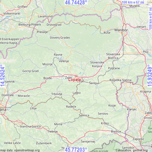
Lopata GPS coordinates[2]
46° 15' 37.116" North, 15° 13' 45.696" East
| Map corner | latitude | longitude |
|---|---|---|
| Upper-left | 46.74428°, | 14.52624° |
| Center: | 46.26031°, | 15.22936° |
| Lower-right: | 45.77203°, | 15.93249° |
| Map W x H: | 108.1×108.1 km | = 67.2×67.2mi |
| max Lat: | 46.83694° ⇑50% North |
| Lopata: | 46.26031° |
| min Lat: | ⇓50% South 45.47667° |
| min Long | Lopata | max Long |
| 13.52639° | 15.22936° | 16.4975° |
| W 62.5%⇐ | ⇒37.5% E |
Elevation
Elevation of Lopata is 248 m = 814 ft, and this is 77.6 m = 255 ft below average elevation for this country.
| Max E: |
1551 m = 5089 ft | 67.7% |
| Avg. | 325.6 m = 1068 ft | |
| Lopata | 248 m = 814 ft | |
Min E: |
2 m = 7 ft | 32.3% |
See also: Slovenia elevation on elevation.city.
Geographical zone
Lopata is located in North temperate zone (between Tropic of Cancer and the Arctic Circle). Distance of this North polar circle is 2257.5 km =1402.7 mi to North.| Distance of | km | miles | from Lopata |
|---|---|---|---|
| North Pole | 4863.4 | 3022 | to North |
| Arctic Circle | 2257.5 | 1402.7 | to North |
| Tropic Cancer | 2537.7 | 1576.9 | to South |
| Equator | 5143.7 | 3196.1 | to South |


Nearby cities:
15 places around Lopata: (largest is in red/bold)
• Arja Vas
3.1 km =1.9 mi,  266°
266°
• Celje
4 km =2.5 mi,  143°
143°
• Galicija
5 km =3.1 mi,  328°
328°
• Gorica pri Šmartnem
1.6 km =1 mi,  4°
4°
• Gotovlje
6.2 km =3.9 mi,  284°
284°
• Kasaze
3.8 km =2.4 mi,  216°
216°
• Košnica pri Celju
4.9 km =3 mi,  176°
176°
• Liboje
6.1 km =3.8 mi,  205°
205°
• Migojnice
5.7 km =3.5 mi,  238°
238°
• Pernovo
4.7 km =2.9 mi,  315°
315°
• Petrovče
3.7 km =2.3 mi, 235°
• Trnovlje pri Celju
5.1 km =3.2 mi,  94°
94°
• Vrbje
6.2 km =3.9 mi,  259°
259°
• Zadobrova
5.8 km =3.6 mi,  83°
83°
• Žalec
5.1 km =3.2 mi, 258°
Sources, notices
• [Note1] Compared only with cities in Slovenia existing in our database
• [Src1] Map data: © OpenStreetMap contributors (CC-BY-SA)
• [Src2] Other city data from geonames.org with taken over terms of usage.
• [Src3] Geographical zone / Annual Mean Temperature by Robert A. Rohde @ Wikipedia
