Moravče geodata
Moravče is a seat of a first-order administrative division; located in Slovenia in Europe/Ljubljana (GMT+2) time zone. With population of 903 people, there are 249 cities with bigger population in this country. Compared to other cities in Slovenia, 65.5% of cities are located further ↑North; 56.2% of cities are located further →East and 72.5% of cities have lower elevation than Moravče. Note1


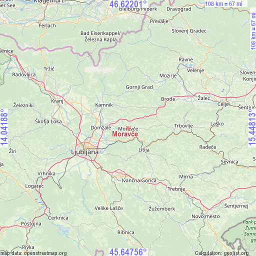
Moravče GPS coordinates[2]
46° 8' 12.984" North, 14° 44' 42" East
| Map corner | latitude | longitude |
|---|---|---|
| Upper-left | 46.62201°, | 14.04188° |
| Center: | 46.13694°, | 14.745° |
| Lower-right: | 45.64756°, | 15.44813° |
| Map W x H: | 108.3×108.3 km | = 67.3×67.3mi |
| max Lat: | 46.83694° ⇑65.5% North |
| Moravče: | 46.13694° |
| min Lat: | ⇓34.5% South 45.47667° |
| min Long | Moravče | max Long |
| 13.52639° | 14.745° | 16.4975° |
| W 43.8%⇐ | ⇒56.2% E |
Elevation
Elevation of Moravče is 383 m = 1257 ft, and this is 57.4 m = 188 ft above average elevation for this country.
| Max E: |
1551 m = 5089 ft | 27.5% |
| Moravče | 383 m 1257 ft | |
| Avg. | 325.6 m = 1068 ft | |
Min E: |
2 m = 7 ft | 72.5% |
See also: Slovenia elevation on elevation.city.
Geographical zone
Moravče is located in North temperate zone (between Tropic of Cancer and the Arctic Circle). Distance of this North polar circle is 2271.2 km =1411.3 mi to North.| Distance of | km | miles | from Moravče |
|---|---|---|---|
| North Pole | 4877.1 | 3030.5 | to North |
| Arctic Circle | 2271.2 | 1411.3 | to North |
| Tropic Cancer | 2524 | 1568.3 | to South |
| Equator | 5129.9 | 3187.6 | to South |


Nearby cities:
15 places around Moravče: (largest is in red/bold)
• Dob
9.1 km =5.7 mi,  280°
280°
• Dolsko
7.2 km =4.5 mi,  226°
226°
• Ihan
9.8 km =6.1 mi,  259°
259°
• Kresnice
5 km =3.1 mi,  141°
141°
• Krtina
7.3 km =4.5 mi, 280°
• Litija
10.6 km =6.6 mi,  145°
145°
• Lukovica pri Domžalah
5.5 km =3.4 mi,  311°
311°
• Prelog
10.3 km =6.4 mi, 263°
• Prevoje pri Šentvidu
6.9 km =4.3 mi,  298°
298°
• Radomlje
11 km =6.8 mi,  291°
291°
• Senožeti
5.1 km =3.2 mi,  190°
190°
• Spodnje Jarše
11.3 km =7 mi, 277°
• Videm
10.3 km =6.4 mi, 234°
• Vir
10.8 km =6.7 mi, 279°
• Zaboršt
10.2 km =6.3 mi,  269°
269°
Sources, notices
• [Note1] Compared only with cities in Slovenia existing in our database
• [Src1] Map data: © OpenStreetMap contributors (CC-BY-SA)
• [Src2] Other city data from geonames.org with taken over terms of usage.
• [Src3] Geographical zone / Annual Mean Temperature by Robert A. Rohde @ Wikipedia
