Loče geodata
Loče (Slovenska Konjice) is a populated place; located in Slovenia in Europe/Ljubljana (GMT+2) time zone. With population of 684 people, there are 366 cities with bigger population in this country. Compared to other cities in Slovenia, 54.3% of cities are located further ↓South; 69% of cities are located further ←West and 61% of cities have higher elevation than Loče. Note1


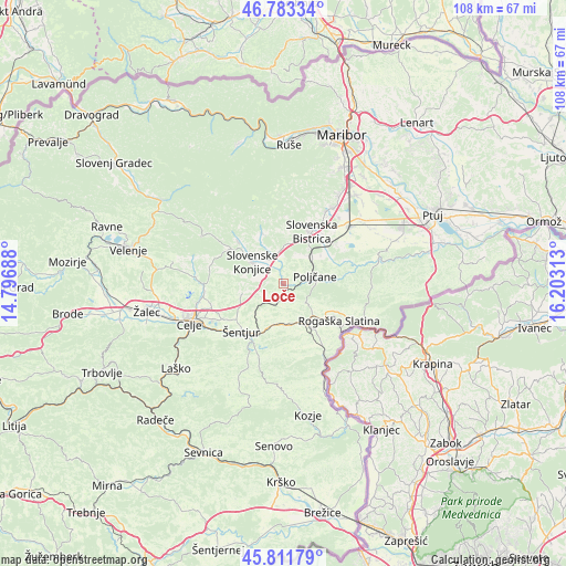
Loče GPS coordinates[2]
46° 17' 58.992" North, 15° 30' 0" East
| Map corner | latitude | longitude |
|---|---|---|
| Upper-left | 46.78334°, | 14.79688° |
| Center: | 46.29972°, | 15.5° |
| Lower-right: | 45.81179°, | 16.20313° |
| Map W x H: | 108×108 km | = 67.1×67.1mi |
| max Lat: | 46.83694° ⇑45.7% North |
| Loče: | 46.29972° |
| min Lat: | ⇓54.3% South 45.47667° |
| min Long | Loče | max Long |
| 13.52639° | 15.5° | 16.4975° |
| W 69%⇐ | ⇒31% E |
Elevation
Elevation of Loče is 270 m = 886 ft, and this is 55.6 m = 182 ft below average elevation for this country.
| Max E: |
1551 m = 5089 ft | 61% |
| Avg. | 325.6 m = 1068 ft | |
| Loče | 270 m = 886 ft | |
Min E: |
2 m = 7 ft | 39% |
See also: Slovenia elevation on elevation.city.
Geographical zone
Loče is located in North temperate zone (between Tropic of Cancer and the Arctic Circle). Distance of this North polar circle is 2253.1 km =1400 mi to North.| Distance of | km | miles | from Loče |
|---|---|---|---|
| North Pole | 4859 | 3019.2 | to North |
| Arctic Circle | 2253.1 | 1400 | to North |
| Tropic Cancer | 2542.1 | 1579.6 | to South |
| Equator | 5148 | 3198.8 | to South |


Nearby cities:
15 places around Loče: (largest is in red/bold)
• Bezina
8.8 km =5.5 mi,  320°
320°
• Draža Vas
4 km =2.5 mi,  341°
341°
• Oplotnica
10.6 km =6.6 mi, 337°
• Poljčane
6.2 km =3.9 mi,  77°
77°
• Slovenska Bistrica
11.8 km =7.3 mi,  28°
28°
• Slovenske Konjice
7 km =4.3 mi,  305°
305°
• Spodnje Poljčane
7.1 km =4.4 mi, 76°
• Tepanje
5.6 km =3.5 mi, 341°
• Visole
11.7 km =7.3 mi,  10°
10°
• Zgornja Bistrica
11.5 km =7.1 mi,  16°
16°
• Zgornje Poljčane
6.3 km =3.9 mi,  87°
87°
• Črešnjevec
12.3 km =7.6 mi,  46°
46°
• Šentjur
12.1 km =7.5 mi,  220°
220°
• Šmarje pri Jelšah
8.2 km =5.1 mi,  169°
169°
• Žiče
2.3 km =1.4 mi, 317°
Sources, notices
• [Note1] Compared only with cities in Slovenia existing in our database
• [Src1] Map data: © OpenStreetMap contributors (CC-BY-SA)
• [Src2] Other city data from geonames.org with taken over terms of usage.
• [Src3] Geographical zone / Annual Mean Temperature by Robert A. Rohde @ Wikipedia
