Kanal geodata
Kanal is a seat of a first-order administrative division; located in Slovenia in Europe/Ljubljana (GMT+2) time zone. With population of 1,269 people, there are 169 cities with bigger population in this country. Compared to other cities in Slovenia, 69% of cities are located further ↑North; 97.7% of cities are located further →East and 82% of cities have higher elevation than Kanal. Note1


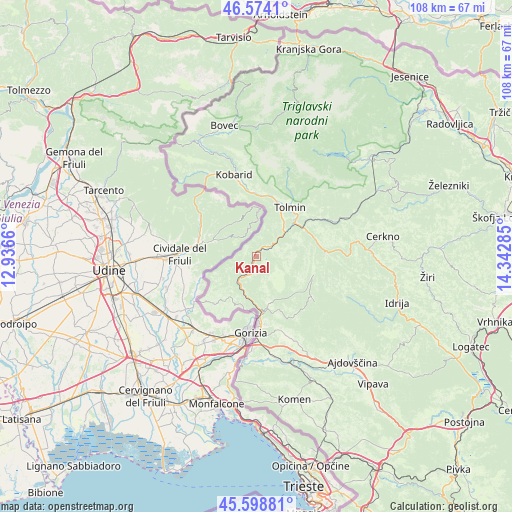
Kanal GPS coordinates[2]
46° 5' 18.996" North, 13° 38' 22.992" East
| Map corner | latitude | longitude |
|---|---|---|
| Upper-left | 46.5741°, | 12.9366° |
| Center: | 46.08861°, | 13.63972° |
| Lower-right: | 45.59881°, | 14.34285° |
| Map W x H: | 108.4×108.4 km | = 67.4×67.4mi |
| max Lat: | 46.83694° ⇑69% North |
| Kanal: | 46.08861° |
| min Lat: | ⇓31% South 45.47667° |
| min Long | Kanal | max Long |
| 13.52639° | 13.63972° | 16.4975° |
| W 2.3%⇐ | ⇒97.7% E |
Elevation
Elevation of Kanal is 190 m = 623 ft, and this is 135.6 m = 445 ft below average elevation for this country.
| Max E: |
1551 m = 5089 ft | 82% |
| Avg. | 325.6 m = 1068 ft | |
| Kanal | 190 m = 623 ft | |
Min E: |
2 m = 7 ft | 18% |
See also: Slovenia elevation on elevation.city.
Geographical zone
Kanal is located in North temperate zone (between Tropic of Cancer and the Arctic Circle). Distance of this North polar circle is 2276.6 km =1414.6 mi to North.| Distance of | km | miles | from Kanal |
|---|---|---|---|
| North Pole | 4882.5 | 3033.8 | to North |
| Arctic Circle | 2276.6 | 1414.6 | to North |
| Tropic Cancer | 2518.7 | 1565 | to South |
| Equator | 5124.6 | 3184.3 | to South |


Nearby cities:
15 places around Kanal: (largest is in red/bold)
• Deskle
4.4 km =2.7 mi,  206°
206°
• Dobrovo
13.5 km =8.4 mi,  220°
220°
• Grgar
10.3 km =6.4 mi,  165°
165°
• Kobarid
18.3 km =11.4 mi,  345°
345°
• Kromberk
14.3 km =8.9 mi, 172°
• Nova Gorica
14.8 km =9.2 mi,  177°
177°
• Ozeljan
17.6 km =10.9 mi,  156°
156°
• Rožna Dolina
16.5 km =10.3 mi, 172°
• Solkan
13.1 km =8.1 mi, 176°
• Tolmin
12.7 km =7.9 mi,  34°
34°
• Vitovlje
19.2 km =11.9 mi,  149°
149°
• Volče
11 km =6.8 mi, 28°
• Vrtojba
19.6 km =12.2 mi, 181°
• Šempas
19.3 km =12 mi, 155°
• Šempeter pri Gorici
17.9 km =11.1 mi, 179°
Sources, notices
• [Note1] Compared only with cities in Slovenia existing in our database
• [Src1] Map data: © OpenStreetMap contributors (CC-BY-SA)
• [Src2] Other city data from geonames.org with taken over terms of usage.
• [Src3] Geographical zone / Annual Mean Temperature by Robert A. Rohde @ Wikipedia
