Jesenice geodata
Jesenice is a seat of a first-order administrative division; located in Slovenia in Europe/Ljubljana (GMT+1) time zone. With population of 13,440 people, there are 10 cities with bigger population in this country. Compared to other cities in Slovenia, 72.2% of cities are located further ↓South; 85.3% of cities are located further →East and 92% of cities have lower elevation than Jesenice. Note1


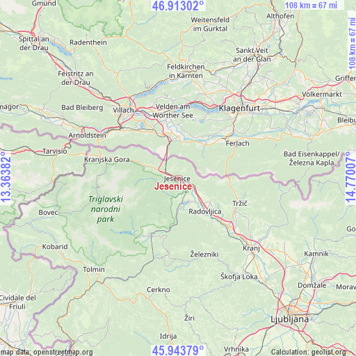
Jesenice GPS coordinates[2]
46° 25' 50.016" North, 14° 4' 0.984" East
| Map corner | latitude | longitude |
|---|---|---|
| Upper-left | 46.91302°, | 13.36382° |
| Center: | 46.43056°, | 14.06694° |
| Lower-right: | 45.94379°, | 14.77007° |
| Map W x H: | 107.8×107.8 km | = 67×67mi |
| max Lat: | 46.83694° ⇑27.8% North |
| Jesenice: | 46.43056° |
| min Lat: | ⇓72.2% South 45.47667° |
| min Long | Jesenice | max Long |
| 13.52639° | 14.06694° | 16.4975° |
| W 14.7%⇐ | ⇒85.3% E |
Elevation
Elevation of Jesenice is 560 m = 1837 ft, and this is 234.4 m = 769 ft above average elevation for this country.
| Max E: |
1551 m = 5089 ft | 8% |
| Jesenice | 560 m 1837 ft | |
| Avg. | 325.6 m = 1068 ft | |
Min E: |
2 m = 7 ft | 92% |
See also: Slovenia elevation on elevation.city.
Geographical zone
Jesenice is located in North temperate zone (between Tropic of Cancer and the Arctic Circle). Distance of this North polar circle is 2238.6 km =1391 mi to North.| Distance of | km | miles | from Jesenice |
|---|---|---|---|
| North Pole | 4844.5 | 3010.2 | to North |
| Arctic Circle | 2238.6 | 1391 | to North |
| Tropic Cancer | 2556.7 | 1588.7 | to South |
| Equator | 5162.6 | 3207.9 | to South |


Nearby cities:
15 places around Jesenice: (largest is in red/bold)
• Bled
7.7 km =4.8 mi,  152°
152°
• Blejska Dobrava
4.2 km =2.6 mi,  143°
143°
• Bohinjska Bela
9.1 km =5.7 mi,  181°
181°
• Breg
6.1 km =3.8 mi,  123°
123°
• Dovje
8.4 km =5.2 mi,  300°
300°
• Hrušica
4.1 km =2.5 mi,  293°
293°
• Koroška Bela
4 km =2.5 mi,  58°
58°
• Moste
5.3 km =3.3 mi,  106°
106°
• Slovenski Javornik
1.6 km =1 mi, 107°
• Smokuč
9 km =5.6 mi, 123°
• Spodnje Gorje
3.1 km =1.9 mi,  232°
232°
• Zabreznica
7.2 km =4.5 mi, 118°
• Zasip
5.3 km =3.3 mi, 142°
• Zgornje Gorje
5.7 km =3.5 mi, 178°
• Žirovnica
6.3 km =3.9 mi, 117°
Sources, notices
• [Note1] Compared only with cities in Slovenia existing in our database
• [Src1] Map data: © OpenStreetMap contributors (CC-BY-SA)
• [Src2] Other city data from geonames.org with taken over terms of usage.
• [Src3] Geographical zone / Annual Mean Temperature by Robert A. Rohde @ Wikipedia
