Smokuč geodata
Smokuč (Žirovnica) is a populated place; located in Slovenia in Europe/Ljubljana (GMT+2) time zone. With population of 527 people, there are 519 cities with bigger population in this country. Compared to other cities in Slovenia, 64.7% of cities are located further ↓South; 82.3% of cities are located further →East and 90.3% of cities have lower elevation than Smokuč. Note1


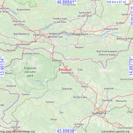
Smokuč GPS coordinates[2]
46° 23' 7.98" North, 14° 9' 52.776" East
| Map corner | latitude | longitude |
|---|---|---|
| Upper-left | 46.86841°, | 13.46154° |
| Center: | 46.38555°, | 14.16466° |
| Lower-right: | 45.89838°, | 14.86779° |
| Map W x H: | 107.9×107.9 km | = 67×67mi |
| max Lat: | 46.83694° ⇑35.3% North |
| Smokuč: | 46.38555° |
| min Lat: | ⇓64.7% South 45.47667° |
| min Long | Smokuč | max Long |
| 13.52639° | 14.16466° | 16.4975° |
| W 17.7%⇐ | ⇒82.3% E |
Elevation
Elevation of Smokuč is 533 m = 1749 ft, and this is 207.4 m = 680 ft above average elevation for this country.
| Max E: |
1551 m = 5089 ft | 9.7% |
| Smokuč | 533 m 1749 ft | |
| Avg. | 325.6 m = 1068 ft | |
Min E: |
2 m = 7 ft | 90.3% |
See also: Slovenia elevation on elevation.city.
Geographical zone
Smokuč is located in North temperate zone (between Tropic of Cancer and the Arctic Circle). Distance of this North polar circle is 2243.6 km =1394.1 mi to North.| Distance of | km | miles | from Smokuč |
|---|---|---|---|
| North Pole | 4849.5 | 3013.3 | to North |
| Arctic Circle | 2243.6 | 1394.1 | to North |
| Tropic Cancer | 2551.7 | 1585.6 | to South |
| Equator | 5157.6 | 3204.8 | to South |


Nearby cities:
15 places around Smokuč: (largest is in red/bold)
• Begunje na Gorenjskem
4 km =2.5 mi,  93°
93°
• Bled
4.3 km =2.7 mi,  245°
245°
• Blejska Dobrava
5.2 km =3.2 mi,  287°
287°
• Breg
2.9 km =1.8 mi,  303°
303°
• Brezje
8.2 km =5.1 mi,  140°
140°
• Kamna Gorica
8.1 km =5 mi,  160°
160°
• Lesce
2.8 km =1.7 mi,  190°
190°
• Moste
4.2 km =2.6 mi,  325°
325°
• Radovljica
4.6 km =2.9 mi,  170°
170°
• Ribno
7.7 km =4.8 mi,  212°
212°
• Slovenski Javornik
7.5 km =4.7 mi,  307°
307°
• Zabreznica
2 km =1.2 mi, 325°
• Zasip
4.4 km =2.7 mi,  280°
280°
• Zgornje Gorje
7.3 km =4.5 mi,  264°
264°
• Žirovnica
2.8 km =1.7 mi,  318°
318°
Sources, notices
• [Note1] Compared only with cities in Slovenia existing in our database
• [Src1] Map data: © OpenStreetMap contributors (CC-BY-SA)
• [Src2] Other city data from geonames.org with taken over terms of usage.
• [Src3] Geographical zone / Annual Mean Temperature by Robert A. Rohde @ Wikipedia
