Radovljica geodata
Radovljica is a seat of a first-order administrative division; located in Slovenia in Europe/Ljubljana (GMT+2) time zone. With population of 5,940 people, there are 31 cities with bigger population in this country. Compared to other cities in Slovenia, 59.5% of cities are located further ↓South; 82% of cities are located further →East and 86.7% of cities have lower elevation than Radovljica. Note1


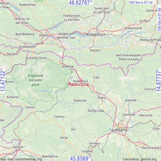
Radovljica GPS coordinates[2]
46° 20' 39.984" North, 14° 10' 27.984" East
| Map corner | latitude | longitude |
|---|---|---|
| Upper-left | 46.82767°, | 13.47132° |
| Center: | 46.34444°, | 14.17444° |
| Lower-right: | 45.8569°, | 14.87757° |
| Map W x H: | 107.9×107.9 km | = 67×67mi |
| max Lat: | 46.83694° ⇑40.5% North |
| Radovljica: | 46.34444° |
| min Lat: | ⇓59.5% South 45.47667° |
| min Long | Radovljica | max Long |
| 13.52639° | 14.17444° | 16.4975° |
| W 18%⇐ | ⇒82% E |
Elevation
Elevation of Radovljica is 489 m = 1604 ft, and this is 163.4 m = 536 ft above average elevation for this country.
| Max E: |
1551 m = 5089 ft | 13.3% |
| Radovljica | 489 m 1604 ft | |
| Avg. | 325.6 m = 1068 ft | |
Min E: |
2 m = 7 ft | 86.7% |
See also: Slovenia elevation on elevation.city.
Geographical zone
Radovljica is located in North temperate zone (between Tropic of Cancer and the Arctic Circle). Distance of this North polar circle is 2248.2 km =1397 mi to North.| Distance of | km | miles | from Radovljica |
|---|---|---|---|
| North Pole | 4854 | 3016.1 | to North |
| Arctic Circle | 2248.2 | 1397 | to North |
| Tropic Cancer | 2547.1 | 1582.7 | to South |
| Equator | 5153 | 3201.9 | to South |


Nearby cities:
15 places around Radovljica: (largest is in red/bold)
• Begunje na Gorenjskem
5.4 km =3.4 mi,  36°
36°
• Bled
5.4 km =3.4 mi,  300°
300°
• Blejska Dobrava
8.4 km =5.2 mi,  317°
317°
• Bohinjska Bela
8.5 km =5.3 mi,  273°
273°
• Breg
6.9 km =4.3 mi,  332°
332°
• Brezje
4.8 km =3 mi,  111°
111°
• Kamna Gorica
3.7 km =2.3 mi,  147°
147°
• Kovor
8.4 km =5.2 mi,  85°
85°
• Kropa
5.3 km =3.3 mi,  158°
158°
• Lesce
2.3 km =1.4 mi, 325°
• Ribno
5.3 km =3.3 mi,  249°
249°
• Smokuč
4.6 km =2.9 mi,  350°
350°
• Zabreznica
6.5 km =4 mi,  343°
343°
• Zasip
7.4 km =4.6 mi, 316°
• Žirovnica
7.2 km =4.5 mi, 338°
Sources, notices
• [Note1] Compared only with cities in Slovenia existing in our database
• [Src1] Map data: © OpenStreetMap contributors (CC-BY-SA)
• [Src2] Other city data from geonames.org with taken over terms of usage.
• [Src3] Geographical zone / Annual Mean Temperature by Robert A. Rohde @ Wikipedia
