Usulután geodata
Usulután is a seat of a first-order administrative division; located in El Salvador in America/El_Salvador (GMT-6) time zone. With population of 51,910 people, there are 10 cities with bigger population in this country. Compared to other cities in El Salvador, 93% of cities are located further ↑North; 71% of cities are located further ←West and 92% of cities have higher elevation than Usulután. Note1


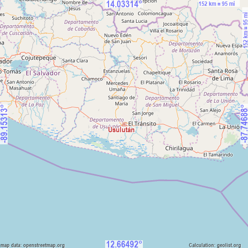
Usulután GPS coordinates[2]
13° 21' 0" North, 88° 27' 0" West
| Map corner | latitude | longitude |
|---|---|---|
| Upper-left | 14.03314°, | -89.15313° |
| Center: | 13.35°, | -88.45° |
| Lower-right: | 12.66492°, | -87.74688° |
| Map W x H: | 152.1×152.1 km | = 94.5×94.5mi |
| max Lat: | 14.33333° ⇑93% North |
| Usulután: | 13.35° |
| min Lat: | ⇓7% South 13.19694° |
| min Long | Usulután | max Long |
| -90.01583° | -88.45° | -87.83861° |
| W 71%⇐ | ⇒29% E |
Elevation
Elevation of Usulután is 105 m = 344 ft, and this is 366.9 m = 1204 ft below average elevation for this country.
| Max E: |
1255 m = 4117 ft | 92% |
| Avg. | 471.9 m = 1548 ft | |
| Usulután | 105 m = 344 ft | |
Min E: |
13 m = 43 ft | 8% |
See also: Usulután elevation on elevation.city.
Geographical zone
Usulután is located in North Torrid zone (between Equator and Tropic of Cancer). Distance of this Northern Tropic circle is 1121.5 km =696.9 mi to North.| Distance of | km | miles | from Usulután |
|---|---|---|---|
| North Pole | 8522.7 | 5295.8 | to North |
| Arctic Circle | 5916.8 | 3676.5 | to North |
| Tropic Cancer | 1121.5 | 696.9 | to North |
| Equator | 1484.4 | 922.4 | to South |


Nearby cities:
15 places around Usulután: (largest is in red/bold)
• Berlín
19 km =11.8 mi,  331°
331°
• Chinameca
19.9 km =12.4 mi,  32°
32°
• Concepción Batres
9 km =5.6 mi,  90°
90°
• El Tránsito
10.8 km =6.7 mi, 90°
• Jiquilisco
14.9 km =9.3 mi,  255°
255°
• Jucuapa
19.9 km =12.4 mi,  21°
21°
• Jucuarán
24.4 km =15.2 mi,  116°
116°
• Lolotique
24.7 km =15.3 mi, 25°
• Nueva Guadalupe
23.1 km =14.4 mi, 27°
• Ozatlán
6.6 km =4.1 mi,  304°
304°
• Puerto El Triunfo
13.1 km =8.1 mi,  235°
235°
• San Agustín
18.7 km =11.6 mi, 299°
• San Rafael Oriente
11.4 km =7.1 mi,  71°
71°
• Santa Elena
5.2 km =3.2 mi,  44°
44°
• Santiago de María
14.9 km =9.3 mi,  353°
353°
Sources, notices
• [Note1] Compared only with cities in El Salvador existing in our database
• [Src1] Map data: © OpenStreetMap contributors (CC-BY-SA)
• [Src2] Other city data from geonames.org with taken over terms of usage.
• [Src3] Geographical zone / Annual Mean Temperature by Robert A. Rohde @ Wikipedia
