Lolotique geodata
Lolotique (San Miguel) is a populated place; located in El Salvador in America/El_Salvador (GMT-6) time zone. With population of 2,654 people, there are 83 cities with bigger population in this country. Compared to other cities in El Salvador, 73% of cities are located further ↑North; 76% of cities are located further ←West and 55% of cities have lower elevation than Lolotique. Note1


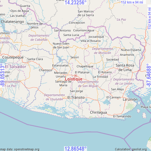
Lolotique GPS coordinates[2]
13° 33' 0" North, 88° 21' 0" West
| Map corner | latitude | longitude |
|---|---|---|
| Upper-left | 14.23256°, | -89.05313° |
| Center: | 13.55°, | -88.35° |
| Lower-right: | 12.86548°, | -87.64688° |
| Map W x H: | 152×152 km | = 94.4×94.4mi |
| max Lat: | 14.33333° ⇑73% North |
| Lolotique: | 13.55° |
| min Lat: | ⇓27% South 13.19694° |
| min Long | Lolotique | max Long |
| -90.01583° | -88.35° | -87.83861° |
| W 76%⇐ | ⇒24% E |
Elevation
Elevation of Lolotique is 527 m = 1729 ft, and this is 55.1 m = 181 ft above average elevation for this country.
| Max E: |
1255 m = 4117 ft | 45% |
| Lolotique | 527 m 1729 ft | |
| Avg. | 471.9 m = 1548 ft | |
Min E: |
13 m = 43 ft | 55% |
See also: El Salvador elevation on elevation.city.
Geographical zone
Lolotique is located in North Torrid zone (between Equator and Tropic of Cancer). Distance of this Northern Tropic circle is 1099.3 km =683.1 mi to North.| Distance of | km | miles | from Lolotique |
|---|---|---|---|
| North Pole | 8500.4 | 5281.9 | to North |
| Arctic Circle | 5894.6 | 3662.7 | to North |
| Tropic Cancer | 1099.3 | 683.1 | to North |
| Equator | 1506.6 | 936.2 | to South |


Nearby cities:
15 places around Lolotique: (largest is in red/bold)
• Berlín
20.6 km =12.8 mi,  254°
254°
• Chapeltique
12.9 km =8 mi,  44°
44°
• Chinameca
5.6 km =3.5 mi,  180°
180°
• Concepción Batres
22.3 km =13.9 mi, 184°
• El Tránsito
22.2 km =13.8 mi, 180°
• Guatajiagua
20.8 km =12.9 mi,  51°
51°
• Jucuapa
5.2 km =3.2 mi,  224°
224°
• Moncagua
11 km =6.8 mi,  99°
99°
• Nueva Guadalupe
1.9 km =1.2 mi, 180°
• Ozatlán
24.6 km =15.3 mi, 221°
• San Miguel
19.5 km =12.1 mi,  112°
112°
• San Rafael Oriente
18.5 km =11.5 mi, 180°
• Santa Elena
19.9 km =12.4 mi,  201°
201°
• Santiago de María
14.6 km =9.1 mi,  239°
239°
• Sesori
18.6 km =11.6 mi,  354°
354°
Sources, notices
• [Note1] Compared only with cities in El Salvador existing in our database
• [Src1] Map data: © OpenStreetMap contributors (CC-BY-SA)
• [Src2] Other city data from geonames.org with taken over terms of usage.
• [Src3] Geographical zone / Annual Mean Temperature by Robert A. Rohde @ Wikipedia
