Yala geodata
Yala is a seat of a first-order administrative division; located in Thailand in Asia/Bangkok (GMT+7) time zone. With population of 93,558 people, there are 22 cities with bigger population in this country. Compared to other cities in Thailand, 97.9% of cities are located further ↑North; 58.9% of cities are located further ←West and 69.2% of cities have higher elevation than Yala. Note1


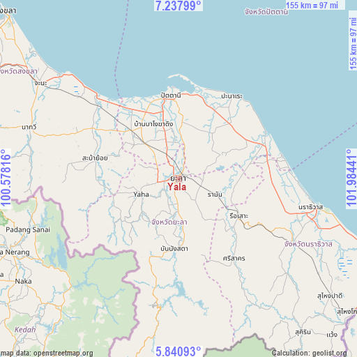
Yala GPS coordinates[2]
6° 32' 23.82" North, 101° 16' 52.608" East
| Map corner | latitude | longitude |
|---|---|---|
| Upper-left | 7.23799°, | 100.57816° |
| Center: | 6.53995°, | 101.28128° |
| Lower-right: | 5.84093°, | 101.98441° |
| Map W x H: | 155.3×155.3 km | = 96.5×96.5mi |
| max Lat: | 20.43353° ⇑97.9% North |
| Yala: | 6.53995° |
| min Lat: | ⇓2.1% South 5.77434° |
| min Long | Yala | max Long |
| 97.93288° | 101.28128° | 105.49506° |
| W 58.9%⇐ | ⇒41.1% E |
Elevation
Elevation of Yala is 24 m = 79 ft, and this is 101.5 m = 333 ft below average elevation for this country.
| Max E: |
1011 m = 3317 ft | 69.2% |
| Avg. | 125.5 m = 412 ft | |
| Yala | 24 m = 79 ft | |
Min E: |
1 m = 3 ft | 30.8% |
See also: Yala elevation on elevation.city.
Geographical zone
Yala is located in North Torrid zone (between Equator and Tropic of Cancer). Distance of Equator is 727.2 km =451.9 mi to South.| Distance of | km | miles | from Yala |
|---|---|---|---|
| North Pole | 9279.9 | 5766.3 | to North |
| Arctic Circle | 6674 | 4147 | to North |
| Tropic Cancer | 1878.7 | 1167.4 | to North |
| Equator | 727.2 | 451.9 | to South |


Nearby cities:
15 places around Yala: (largest is in red/bold)
• Ban Nang Sata
30.5 km =19 mi,  183°
183°
• Ka Bang
28.6 km =17.8 mi,  241°
241°
• Kapho
28 km =17.4 mi,  85°
85°
• Khok Pho
29.5 km =18.3 mi,  316°
316°
• Krong Pi Nang
14.3 km =8.9 mi, 183°
• Mae Lan
14.2 km =8.8 mi,  341°
341°
• Mayo
24.4 km =15.2 mi,  35°
35°
• Nong Chik
35.6 km =22.1 mi, 341°
• Pattani
36.7 km =22.8 mi,  354°
354°
• Raman
17.2 km =10.7 mi,  113°
113°
• Rueso
30.8 km =19.1 mi,  121°
121°
• Saba Yoi
37.4 km =23.2 mi,  283°
283°
• Thung Yang Daeng
18.2 km =11.3 mi,  61°
61°
• Yaha
17.8 km =11.1 mi,  247°
247°
• Yarang
24.5 km =15.2 mi,  3°
3°
Sources, notices
• [Note1] Compared only with cities in Thailand existing in our database
• [Src1] Map data: © OpenStreetMap contributors (CC-BY-SA)
• [Src2] Other city data from geonames.org with taken over terms of usage.
• [Src3] Geographical zone / Annual Mean Temperature by Robert A. Rohde @ Wikipedia
