Khok Pho geodata
Khok Pho (Pattani) is a seat of a second-order administrative division; located in Thailand in Asia/Bangkok (GMT+7) time zone. In our database, there are 331 cities with bigger population. Compared to other cities in Thailand, 96.4% of cities are located further ↑North; 56% of cities are located further ←West and 65.8% of cities have higher elevation than Khok Pho. Note1


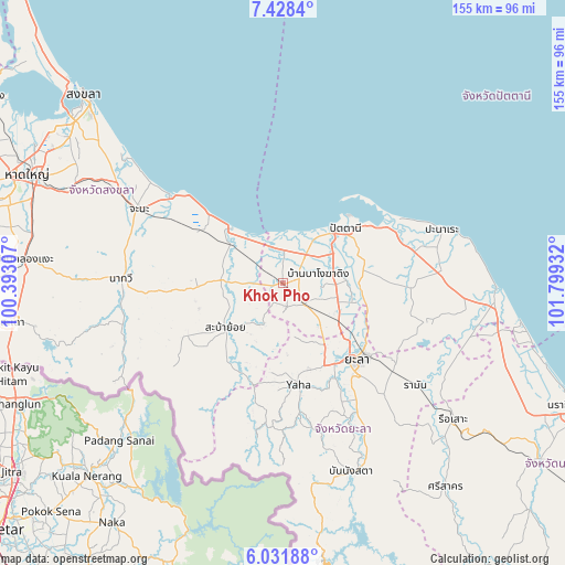
Khok Pho GPS coordinates[2]
6° 43' 50.304" North, 101° 5' 46.284" East
| Map corner | latitude | longitude |
|---|---|---|
| Upper-left | 7.4284°, | 100.39307° |
| Center: | 6.73064°, | 101.09619° |
| Lower-right: | 6.03188°, | 101.79932° |
| Map W x H: | 155.3×155.3 km | = 96.5×96.5mi |
| max Lat: | 20.43353° ⇑96.4% North |
| Khok Pho: | 6.73064° |
| min Lat: | ⇓3.6% South 5.77434° |
| min Long | Khok Pho | max Long |
| 97.93288° | 101.09619° | 105.49506° |
| W 56%⇐ | ⇒44% E |
Elevation
Elevation of Khok Pho is 30 m = 98 ft, and this is 95.5 m = 313 ft below average elevation for this country.
| Max E: |
1011 m = 3317 ft | 65.8% |
| Avg. | 125.5 m = 412 ft | |
| Khok Pho | 30 m = 98 ft | |
Min E: |
1 m = 3 ft | 34.2% |
See also: Thailand elevation on elevation.city.
Geographical zone
Khok Pho is located in North Torrid zone (between Equator and Tropic of Cancer). Distance of Equator is 748.4 km =465 mi to South.| Distance of | km | miles | from Khok Pho |
|---|---|---|---|
| North Pole | 9258.7 | 5753.1 | to North |
| Arctic Circle | 6652.8 | 4133.9 | to North |
| Tropic Cancer | 1857.5 | 1154.2 | to North |
| Equator | 748.4 | 465 | to South |


Nearby cities:
15 places around Khok Pho: (largest is in red/bold)
• Chana
44.3 km =27.5 mi,  297°
297°
• Ka Bang
35.4 km =22 mi,  187°
187°
• Krong Pi Nang
40.6 km =25.2 mi,  151°
151°
• Mae Lan
17.6 km =10.9 mi,  116°
116°
• Mayo
34.7 km =21.6 mi,  92°
92°
• Na Thawi
44.7 km =27.8 mi,  271°
271°
• Nong Chik
15.5 km =9.6 mi,  35°
35°
• Pattani
22.9 km =14.2 mi,  48°
48°
• Saba Yoi
20.3 km =12.6 mi,  231°
231°
• Thepha
18.2 km =11.3 mi,  307°
307°
• Thung Yang Daeng
38.6 km =24 mi,  108°
108°
• Yaha
28.2 km =17.5 mi,  171°
171°
• Yala
29.5 km =18.3 mi,  136°
136°
• Yarang
22 km =13.7 mi,  81°
81°
• Yaring
33.7 km =20.9 mi,  63°
63°
Sources, notices
• [Note1] Compared only with cities in Thailand existing in our database
• [Src1] Map data: © OpenStreetMap contributors (CC-BY-SA)
• [Src2] Other city data from geonames.org with taken over terms of usage.
• [Src3] Geographical zone / Annual Mean Temperature by Robert A. Rohde @ Wikipedia
