Tak Bai geodata
Tak Bai (Narathiwat) is a seat of a second-order administrative division; located in Thailand in Asia/Bangkok (GMT+7) time zone. With population of 17,241 people, there are 185 cities with bigger population in this country. Compared to other cities in Thailand, 99% of cities are located further ↑North; 67.2% of cities are located further ←West and 88.1% of cities have higher elevation than Tak Bai. Note1


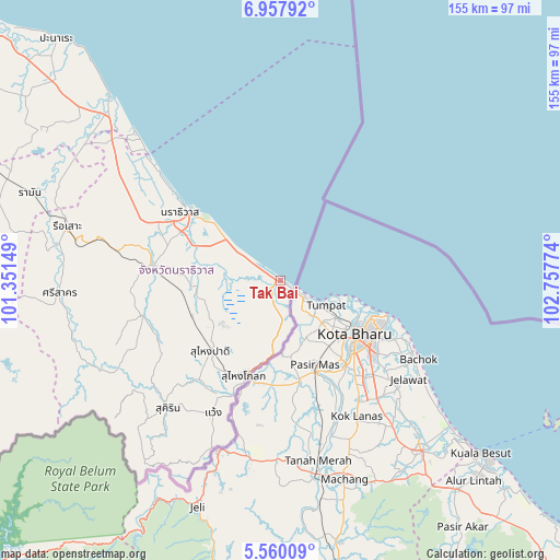
Tak Bai GPS coordinates[2]
6° 15' 34.092" North, 102° 3' 16.596" East
| Map corner | latitude | longitude |
|---|---|---|
| Upper-left | 6.95792°, | 101.35149° |
| Center: | 6.25947°, | 102.05461° |
| Lower-right: | 5.56009°, | 102.75774° |
| Map W x H: | 155.4×155.4 km | = 96.6×96.6mi |
| max Lat: | 20.43353° ⇑99% North |
| Tak Bai: | 6.25947° |
| min Lat: | ⇓1% South 5.77434° |
| min Long | Tak Bai | max Long |
| 97.93288° | 102.05461° | 105.49506° |
| W 67.2%⇐ | ⇒32.8% E |
Elevation
Elevation of Tak Bai is 9 m = 30 ft, and this is 116.5 m = 382 ft below average elevation for this country.
| Max E: |
1011 m = 3317 ft | 88.1% |
| Avg. | 125.5 m = 412 ft | |
| Tak Bai | 9 m = 30 ft | |
Min E: |
1 m = 3 ft | 11.9% |
See also: Thailand elevation on elevation.city.
Geographical zone
Tak Bai is located in North Torrid zone (between Equator and Tropic of Cancer). Distance of Equator is 696 km =432.5 mi to South.| Distance of | km | miles | from Tak Bai |
|---|---|---|---|
| North Pole | 9311.1 | 5785.6 | to North |
| Arctic Circle | 6705.2 | 4166.4 | to North |
| Tropic Cancer | 1909.9 | 1186.8 | to North |
| Equator | 696 | 432.5 | to South |


Nearby cities:
15 places around Tak Bai: (largest is in red/bold)
• Bacho
53 km =32.9 mi,  302°
302°
• Ban Su-ngai Pa Di
29 km =18 mi,  224°
224°
• Chanae
43.7 km =27.2 mi,  245°
245°
• Cho-airong
27.2 km =16.9 mi,  262°
262°
• Kapho
66.5 km =41.3 mi, 300°
• Mai Kaen
57.9 km =36 mi,  312°
312°
• Narathiwat
31.6 km =19.6 mi, 305°
• Ra-ngae
36.3 km =22.6 mi,  276°
276°
• Rueso
61.1 km =38 mi, 284°
• Si Sakhon
61.3 km =38.1 mi,  267°
267°
• Su-ngai Kolok
27.4 km =17 mi,  201°
201°
• Su-ngai Padi
27.3 km =17 mi,  225°
225°
• Sukhirin
47.5 km =29.5 mi, 221°
• Waeng
41.4 km =25.7 mi,  207°
207°
• Yi-ngo
41.7 km =25.9 mi,  292°
292°
Sources, notices
• [Note1] Compared only with cities in Thailand existing in our database
• [Src1] Map data: © OpenStreetMap contributors (CC-BY-SA)
• [Src2] Other city data from geonames.org with taken over terms of usage.
• [Src3] Geographical zone / Annual Mean Temperature by Robert A. Rohde @ Wikipedia
