Ra-ngae geodata
Ra-ngae (Narathiwat) is a seat of a second-order administrative division; located in Thailand in Asia/Bangkok (GMT+7) time zone. With population of 16,862 people, there are 190 cities with bigger population in this country. Compared to other cities in Thailand, 98.8% of cities are located further ↑North; 63.9% of cities are located further ←West and 68.7% of cities have higher elevation than Ra-ngae. Note1


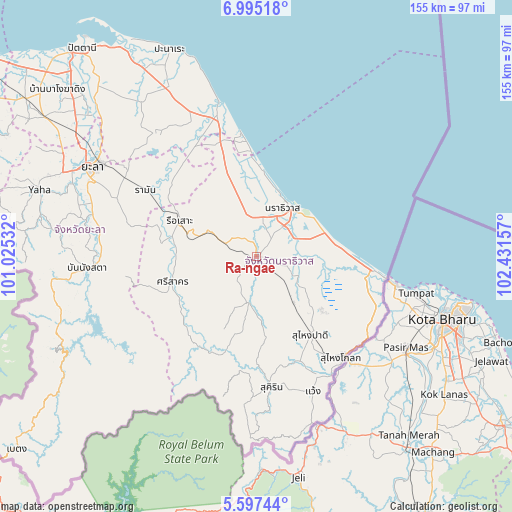
Ra-ngae GPS coordinates[2]
6° 17' 48.408" North, 101° 43' 42.384" East
| Map corner | latitude | longitude |
|---|---|---|
| Upper-left | 6.99518°, | 101.02532° |
| Center: | 6.29678°, | 101.72844° |
| Lower-right: | 5.59744°, | 102.43157° |
| Map W x H: | 155.4×155.4 km | = 96.6×96.6mi |
| max Lat: | 20.43353° ⇑98.8% North |
| Ra-ngae: | 6.29678° |
| min Lat: | ⇓1.2% South 5.77434° |
| min Long | Ra-ngae | max Long |
| 97.93288° | 101.72844° | 105.49506° |
| W 63.9%⇐ | ⇒36.1% E |
Elevation
Elevation of Ra-ngae is 25 m = 82 ft, and this is 100.5 m = 330 ft below average elevation for this country.
| Max E: |
1011 m = 3317 ft | 68.7% |
| Avg. | 125.5 m = 412 ft | |
| Ra-ngae | 25 m = 82 ft | |
Min E: |
1 m = 3 ft | 31.3% |
See also: Thailand elevation on elevation.city.
Geographical zone
Ra-ngae is located in North Torrid zone (between Equator and Tropic of Cancer). Distance of Equator is 700.1 km =435 mi to South.| Distance of | km | miles | from Ra-ngae |
|---|---|---|---|
| North Pole | 9306.9 | 5783 | to North |
| Arctic Circle | 6701 | 4163.8 | to North |
| Tropic Cancer | 1905.8 | 1184.2 | to North |
| Equator | 700.1 | 435 | to South |


Nearby cities:
15 places around Ra-ngae: (largest is in red/bold)
• Bacho
25.9 km =16.1 mi,  340°
340°
• Ban Su-ngai Pa Di
29.6 km =18.4 mi,  147°
147°
• Chanae
22.3 km =13.9 mi,  189°
189°
• Cho-airong
12.1 km =7.5 mi,  130°
130°
• Kapho
36.3 km =22.6 mi,  323°
323°
• Mai Kaen
35.5 km =22.1 mi,  348°
348°
• Narathiwat
17.8 km =11.1 mi,  35°
35°
• Raman
39.2 km =24.4 mi,  301°
301°
• Rueso
25.6 km =15.9 mi,  294°
294°
• Si Sakhon
26.2 km =16.3 mi,  253°
253°
• Su-ngai Kolok
39.6 km =24.6 mi,  138°
138°
• Su-ngai Padi
28.8 km =17.9 mi, 144°
• Sukhirin
40.1 km =24.9 mi,  173°
173°
• Tak Bai
36.3 km =22.6 mi,  96°
96°
• Yi-ngo
12.1 km =7.5 mi, 348°
Sources, notices
• [Note1] Compared only with cities in Thailand existing in our database
• [Src1] Map data: © OpenStreetMap contributors (CC-BY-SA)
• [Src2] Other city data from geonames.org with taken over terms of usage.
• [Src3] Geographical zone / Annual Mean Temperature by Robert A. Rohde @ Wikipedia
