Tepeköy geodata
Tepeköy (Şırnak) is a populated place; located in Turkey in Europe/Istanbul (GMT+3) time zone. With population of 857 people, there are 1130 cities with bigger population in this country. Compared to other cities in Turkey, 80.5% of cities are located further ↑North; 88.7% of cities are located further ←West and 57.3% of cities have lower elevation than Tepeköy. Note1


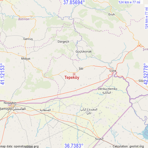
Tepeköy GPS coordinates[2]
37° 17' 58.92" North, 41° 49' 28.74" East
| Map corner | latitude | longitude |
|---|---|---|
| Upper-left | 37.85694°, | 41.12153° |
| Center: | 37.2997°, | 41.82465° |
| Lower-right: | 36.7383°, | 42.52778° |
| Map W x H: | 124.4×124.4 km | = 77.3×77.3mi |
| max Lat: | 42.02683° ⇑80.5% North |
| Tepeköy: | 37.2997° |
| min Lat: | ⇓19.5% South 35.9025° |
| min Long | Tepeköy | max Long |
| 25.90902° | 41.82465° | 44.60099° |
| W 88.7%⇐ | ⇒11.3% E |
Elevation
Elevation of Tepeköy is 830 m = 2723 ft, and this is 112.6 m = 369 ft above average elevation for this country.
| Max E: |
2682 m = 8799 ft | 42.7% |
| Tepeköy | 830 m 2723 ft | |
| Avg. | 717.4 m = 2354 ft | |
Min E: |
0 m = 0 ft | 57.3% |
See also: Turkey elevation on elevation.city.
Geographical zone
Tepeköy is located in North temperate zone (between Tropic of Cancer and the Arctic Circle). Distance of this Northern Tropic circle is 1541.4 km =957.8 mi to South.| Distance of | km | miles | from Tepeköy |
|---|---|---|---|
| North Pole | 5859.7 | 3641 | to North |
| Arctic Circle | 3253.8 | 2021.8 | to North |
| Tropic Cancer | 1541.4 | 957.8 | to South |
| Equator | 4147.3 | 2577 | to South |


Nearby cities:
15 places around Tepeköy: (largest is in red/bold)
• Barim
10.3 km =6.4 mi,  105°
105°
• Dumanlı
14.1 km =8.8 mi,  302°
302°
• Duruköy
11.7 km =7.3 mi,  135°
135°
• Karalar
13.2 km =8.2 mi,  270°
270°
• Ortaköy
13.5 km =8.4 mi,  130°
130°
• Oyalı
11.6 km =7.2 mi,  221°
221°
• Oymak
6.2 km =3.9 mi,  147°
147°
• Ozan
14.3 km =8.9 mi, 106°
• Pınarbaşı
11 km =6.8 mi, 150°
• Ulak
3.7 km =2.3 mi,  214°
214°
• Uğrak
12.6 km =7.8 mi,  204°
204°
• Varımlı
12.3 km =7.6 mi,  176°
176°
• Yarbaşı
10.8 km =6.7 mi,  19°
19°
• Yazman
8.1 km =5 mi, 223°
• İdil
6.9 km =4.3 mi,  55°
55°
Sources, notices
• [Note1] Compared only with cities in Turkey existing in our database
• [Src1] Map data: © OpenStreetMap contributors (CC-BY-SA)
• [Src2] Other city data from geonames.org with taken over terms of usage.
• [Src3] Geographical zone / Annual Mean Temperature by Robert A. Rohde @ Wikipedia
