Yarbaşı geodata
Yarbaşı (Şırnak) is a populated place; located in Turkey in Europe/Istanbul (GMT+3) time zone. With population of 652 people, there are 1226 cities with bigger population in this country. Compared to other cities in Turkey, 77.8% of cities are located further ↑North; 89.1% of cities are located further ←West and 54.3% of cities have lower elevation than Yarbaşı. Note1


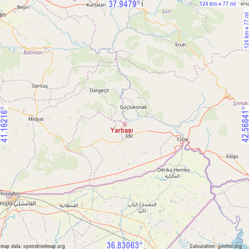
Yarbaşı GPS coordinates[2]
37° 23' 28.86" North, 41° 51' 55.008" East
| Map corner | latitude | longitude |
|---|---|---|
| Upper-left | 37.9479°, | 41.16216° |
| Center: | 37.39135°, | 41.86528° |
| Lower-right: | 36.83063°, | 42.56841° |
| Map W x H: | 124.2×124.2 km | = 77.2×77.2mi |
| max Lat: | 42.02683° ⇑77.8% North |
| Yarbaşı: | 37.39135° |
| min Lat: | ⇓22.2% South 35.9025° |
| min Long | Yarbaşı | max Long |
| 25.90902° | 41.86528° | 44.60099° |
| W 89.1%⇐ | ⇒10.9% E |
Elevation
Elevation of Yarbaşı is 782 m = 2566 ft, and this is 64.6 m = 212 ft above average elevation for this country.
| Max E: |
2682 m = 8799 ft | 45.7% |
| Yarbaşı | 782 m 2566 ft | |
| Avg. | 717.4 m = 2354 ft | |
Min E: |
0 m = 0 ft | 54.3% |
See also: Turkey elevation on elevation.city.
Geographical zone
Yarbaşı is located in North temperate zone (between Tropic of Cancer and the Arctic Circle). Distance of this Northern Tropic circle is 1551.6 km =964.1 mi to South.| Distance of | km | miles | from Yarbaşı |
|---|---|---|---|
| North Pole | 5849.5 | 3634.7 | to North |
| Arctic Circle | 3243.6 | 2015.5 | to North |
| Tropic Cancer | 1551.6 | 964.1 | to South |
| Equator | 4157.5 | 2583.3 | to South |


Nearby cities:
15 places around Yarbaşı: (largest is in red/bold)
• Akdizgin
9.8 km =6.1 mi,  59°
59°
• Baraniferho
9.4 km =5.8 mi,  22°
22°
• Barim
14.4 km =8.9 mi,  153°
153°
• Boyuncuk
5.4 km =3.4 mi,  45°
45°
• Dumanlı
15.7 km =9.8 mi,  260°
260°
• Fındık
16.1 km =10 mi,  32°
32°
• Koçtepe
16.9 km =10.5 mi,  0°
0°
• Kılavuz
12.2 km =7.6 mi,  323°
323°
• Oymak
15.5 km =9.6 mi,  181°
181°
• Ozan
17.5 km =10.9 mi,  144°
144°
• Sulak
8.8 km =5.5 mi,  73°
73°
• Tepeköy
10.8 km =6.7 mi,  199°
199°
• Tililan
15 km =9.3 mi,  97°
97°
• Ulak
14.4 km =8.9 mi, 203°
• İdil
6.6 km =4.1 mi,  161°
161°
Sources, notices
• [Note1] Compared only with cities in Turkey existing in our database
• [Src1] Map data: © OpenStreetMap contributors (CC-BY-SA)
• [Src2] Other city data from geonames.org with taken over terms of usage.
• [Src3] Geographical zone / Annual Mean Temperature by Robert A. Rohde @ Wikipedia
