Çınar geodata
Çınar (Diyarbakır) is a seat of a second-order administrative division; located in Turkey in Europe/Istanbul (GMT+3) time zone. In our database, there are 1323 cities with bigger population. Compared to other cities in Turkey, 70% of cities are located further ↑North; 75.9% of cities are located further ←West and 51.9% of cities have higher elevation than Çınar. Note1


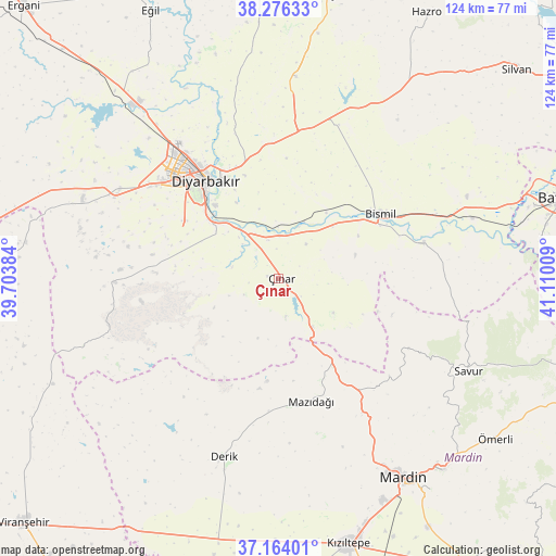
Çınar GPS coordinates[2]
37° 43' 20.136" North, 40° 24' 25.056" East
| Map corner | latitude | longitude |
|---|---|---|
| Upper-left | 38.27633°, | 39.70384° |
| Center: | 37.72226°, | 40.40696° |
| Lower-right: | 37.16401°, | 41.11009° |
| Map W x H: | 123.7×123.7 km | = 76.9×76.9mi |
| max Lat: | 42.02683° ⇑70% North |
| Çınar: | 37.72226° |
| min Lat: | ⇓30% South 35.9025° |
| min Long | Çınar | max Long |
| 25.90902° | 40.40696° | 44.60099° |
| W 75.9%⇐ | ⇒24.1% E |
Elevation
Elevation of Çınar is 658 m = 2159 ft, and this is 59.4 m = 195 ft below average elevation for this country.
| Max E: |
2682 m = 8799 ft | 51.9% |
| Avg. | 717.4 m = 2354 ft | |
| Çınar | 658 m = 2159 ft | |
Min E: |
0 m = 0 ft | 48.1% |
See also: Turkey elevation on elevation.city.
Geographical zone
Çınar is located in North temperate zone (between Tropic of Cancer and the Arctic Circle). Distance of this Northern Tropic circle is 1588.4 km =987 mi to South.| Distance of | km | miles | from Çınar |
|---|---|---|---|
| North Pole | 5812.7 | 3611.8 | to North |
| Arctic Circle | 3206.9 | 1992.7 | to North |
| Tropic Cancer | 1588.4 | 987 | to South |
| Equator | 4194.3 | 2606.2 | to South |


Nearby cities:
15 places around Çınar: (largest is in red/bold)
• Ambar
18 km =11.2 mi,  36°
36°
• Aralık
26.8 km =16.7 mi,  63°
63°
• Bağlar
27.7 km =17.2 mi,  320°
320°
• Bismil
26 km =16.2 mi, 58°
• Diyarbakır
27 km =16.8 mi, 321°
• Kavsan
23.3 km =14.5 mi,  108°
108°
• Kazancı
17.8 km =11.1 mi,  72°
72°
• Kerh
16.7 km =10.4 mi,  46°
46°
• Köseli
21.9 km =13.6 mi, 53°
• Mazıdağı
27.9 km =17.3 mi,  166°
166°
• Meydanlık
21.8 km =13.5 mi,  80°
80°
• Sur
26.4 km =16.4 mi, 323°
• Türkmenhacı
20.3 km =12.6 mi, 62°
• Yaprakbaşı
14.4 km =8.9 mi,  121°
121°
• Şenocak
26.5 km =16.5 mi, 107°
Sources, notices
• [Note1] Compared only with cities in Turkey existing in our database
• [Src1] Map data: © OpenStreetMap contributors (CC-BY-SA)
• [Src2] Other city data from geonames.org with taken over terms of usage.
• [Src3] Geographical zone / Annual Mean Temperature by Robert A. Rohde @ Wikipedia
