Türkmenhacı geodata
Türkmenhacı (Diyarbakır) is a populated place; located in Turkey in Europe/Istanbul (GMT+3) time zone. With population of 892 people, there are 1120 cities with bigger population in this country. Compared to other cities in Turkey, 68.3% of cities are located further ↑North; 77.3% of cities are located further ←West and 54.7% of cities have higher elevation than Türkmenhacı. Note1


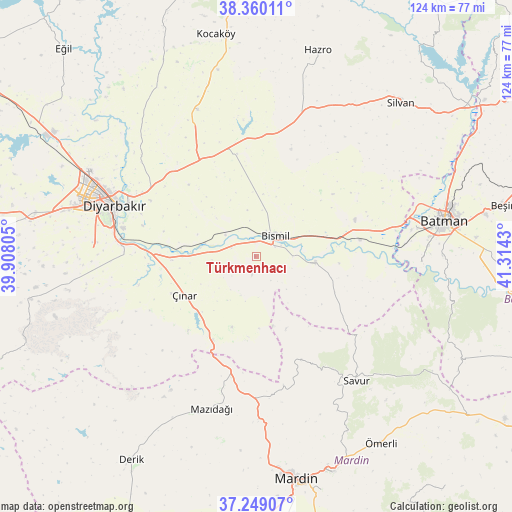
Türkmenhacı GPS coordinates[2]
37° 48' 24.048" North, 40° 36' 40.212" East
| Map corner | latitude | longitude |
|---|---|---|
| Upper-left | 38.36011°, | 39.90805° |
| Center: | 37.80668°, | 40.61117° |
| Lower-right: | 37.24907°, | 41.3143° |
| Map W x H: | 123.5×123.5 km | = 76.7×76.7mi |
| max Lat: | 42.02683° ⇑68.3% North |
| Türkmenhacı: | 37.80668° |
| min Lat: | ⇓31.7% South 35.9025° |
| min Long | Türkmenhacı | max Long |
| 25.90902° | 40.61117° | 44.60099° |
| W 77.3%⇐ | ⇒22.7% E |
Elevation
Elevation of Türkmenhacı is 600 m = 1969 ft, and this is 117.4 m = 385 ft below average elevation for this country.
| Max E: |
2682 m = 8799 ft | 54.7% |
| Avg. | 717.4 m = 2354 ft | |
| Türkmenhacı | 600 m = 1969 ft | |
Min E: |
0 m = 0 ft | 45.3% |
See also: Turkey elevation on elevation.city.
Geographical zone
Türkmenhacı is located in North temperate zone (between Tropic of Cancer and the Arctic Circle). Distance of this Northern Tropic circle is 1597.8 km =992.8 mi to South.| Distance of | km | miles | from Türkmenhacı |
|---|---|---|---|
| North Pole | 5803.4 | 3606.1 | to North |
| Arctic Circle | 3197.5 | 1986.8 | to North |
| Tropic Cancer | 1597.8 | 992.8 | to South |
| Equator | 4203.7 | 2612.1 | to South |


Nearby cities:
15 places around Türkmenhacı: (largest is in red/bold)
• Ambar
8.9 km =5.5 mi,  305°
305°
• Aralık
6.6 km =4.1 mi,  67°
67°
• Bismil
6 km =3.7 mi,  44°
44°
• Doruk
19.7 km =12.2 mi,  126°
126°
• Harmanlı
21.1 km =13.1 mi,  114°
114°
• Kavsan
17.2 km =10.7 mi,  166°
166°
• Kazancı
4.1 km =2.5 mi,  193°
193°
• Kerh
6.3 km =3.9 mi,  289°
289°
• Köseli
3.6 km =2.2 mi,  355°
355°
• Meydanlık
6.8 km =4.2 mi,  148°
148°
• Tepe
14.2 km =8.8 mi,  97°
97°
• Yaprakbaşı
17.9 km =11.1 mi,  198°
198°
• Yukarı Harım
15 km =9.3 mi,  34°
34°
• Çınar
20.3 km =12.6 mi,  242°
242°
• Şenocak
18.9 km =11.7 mi,  157°
157°
Sources, notices
• [Note1] Compared only with cities in Turkey existing in our database
• [Src1] Map data: © OpenStreetMap contributors (CC-BY-SA)
• [Src2] Other city data from geonames.org with taken over terms of usage.
• [Src3] Geographical zone / Annual Mean Temperature by Robert A. Rohde @ Wikipedia
