Nantou geodata
Nantou (Taiwan) is a seat of a second-order administrative division; located in Taiwan in Asia/Taipei (GMT+8) time zone. With population of 105,682 people, there are 11 cities with bigger population in this country. Compared to other cities in Taiwan, 56.8% of cities are located further ↑North; 56.8% of cities are located further →East and 89.2% of cities have lower elevation than Nantou. Note1


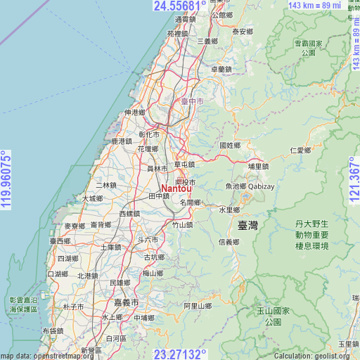
Nantou GPS coordinates[2]
23° 54' 56.376" North, 120° 39' 49.932" East
| Map corner | latitude | longitude |
|---|---|---|
| Upper-left | 24.55681°, | 119.96075° |
| Center: | 23.91566°, | 120.66387° |
| Lower-right: | 23.27132°, | 121.367° |
| Map W x H: | 142.9×142.9 km | = 88.8×88.8mi |
| max Lat: | 26.15039° ⇑56.8% North |
| Nantou: | 23.91566° |
| min Lat: | ⇓43.2% South 22.00417° |
| min Long | Nantou | max Long |
| 118.31712° | 120.66387° | 121.84424° |
| W 43.2%⇐ | ⇒56.8% E |
Elevation
Elevation of Nantou is 196 m = 643 ft, and this is 117.5 m = 385 ft above average elevation for this country.
| Max E: |
505 m = 1657 ft | 10.8% |
| Nantou | 196 m 643 ft | |
| Avg. | 78.5 m = 258 ft | |
Min E: |
8 m = 26 ft | 89.2% |
See also: Nantou elevation on elevation.city.
Geographical zone
Nantou is located in North temperate zone (between Tropic of Cancer and the Arctic Circle). Distance of this Northern Tropic circle is 53.3 km =33.1 mi to South.| Distance of | km | miles | from Nantou |
|---|---|---|---|
| North Pole | 7347.9 | 4565.8 | to North |
| Arctic Circle | 4742 | 2946.5 | to North |
| Tropic Cancer | 53.3 | 33.1 | to South |
| Equator | 2659.2 | 1652.3 | to South |


Nearby cities:
15 places around Nantou: (largest is in red/bold)
• Chang-hua
20.3 km =12.6 mi,  329°
329°
• Douliu
26 km =16.2 mi,  208°
208°
• Fengyuan
37.6 km =23.4 mi,  8°
8°
• Hualien City
95.8 km =59.5 mi,  85°
85°
• Jiayi Shi
53.2 km =33.1 mi,  204°
204°
• Lugu
20.9 km =13 mi,  154°
154°
• Miaoli
73.9 km =45.9 mi, 12°
• Pizitou
52.8 km =32.8 mi, 205°
• Puli
31.6 km =19.6 mi,  79°
79°
• Taibao
60.9 km =37.8 mi, 213°
• Taichung
25.8 km =16 mi,  4°
4°
• Xinying
76.7 km =47.7 mi, 208°
• Yuanlin
10 km =6.2 mi,  297°
297°
• Yujing
90.3 km =56.1 mi,  193°
193°
• Zhongxing New Village
5.3 km =3.3 mi,  24°
24°
In other languages:
- In Russian: Наньтоу
- In Chinese: Nan-t’ou-chieh, Nan-t’ou-hsien, 南投, Nan-t’ou-shih, Nan-t’ou, 南投市
Sources, notices
• [Note1] Compared only with cities in Taiwan existing in our database
• [Src1] Map data: © OpenStreetMap contributors (CC-BY-SA)
• [Src2] Other city data from geonames.org with taken over terms of usage.
• [Src3] Geographical zone / Annual Mean Temperature by Robert A. Rohde @ Wikipedia
