Zavet-Leninskiy geodata
Zavet-Leninskiy (Republic of Crimea) is a seat of a third-order administrative division; located in Ukraine in Europe/Simferopol (GMT+3) time zone. With population of 2,222 people, there are 1073 cities with bigger population in this country. Compared to other cities in Ukraine, 71.1% of cities are located further ↑North; 71.8% of cities are located further ←West and 99% of cities have higher elevation than Zavet-Leninskiy. Note1
Administrative division(s):
- Level 1: Republic of Crimea
- Level 2: Dzhankoyskiy rayon
- Level 3: Zavet-Leninskoye sel'skoye poselenye


Zavet-Leninskiy GPS coordinates[2]
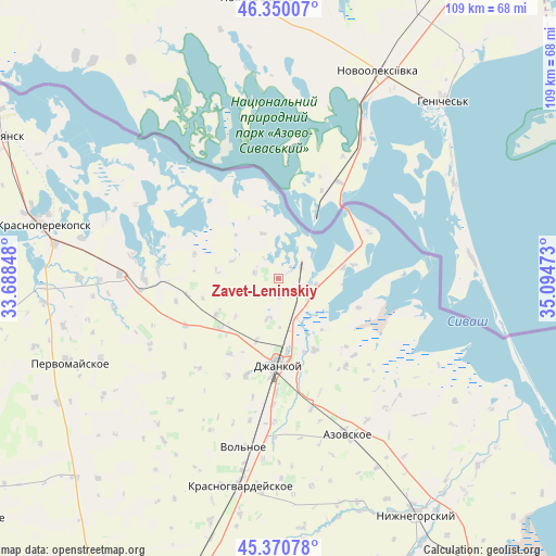
45° 51' 45.288" North, 34° 23' 29.76" East
| Map corner | latitude | longitude |
|---|---|---|
| Upper-left | 46.35007°, | 33.68848° |
| Center: | 45.86258°, | 34.3916° |
| Lower-right: | 45.37078°, | 35.09473° |
| Map W x H: | 108.9×108.9 km | = 67.7×67.7mi |
| max Lat: | 52.18903° ⇑71.1% North |
| Zavet-Leninskiy: | 45.86258° |
| min Lat: | ⇓28.9% South 44.39214° |
| min Long | Zavet-Leninskiy | max Long |
| 22.20555° | 34.3916° | 40.13222° |
| W 71.8%⇐ | ⇒28.2% E |
Elevation
Elevation of Zavet-Leninskiy is 5 m = 16 ft, and this is 150.8 m = 495 ft below average elevation for this country.
| Max E: |
886 m = 2907 ft | 99% |
| Avg. | 155.8 m = 511 ft | |
| Zavet-Leninskiy | 5 m = 16 ft | |
Min E: |
-3 m = -10 ft | 1% |
See also: Ukraine elevation on elevation.city.
Geographical zone
Zavet-Leninskiy is located in North temperate zone (between Tropic of Cancer and the Arctic Circle). Distance of this North polar circle is 2301.7 km =1430.2 mi to North.| Distance of | km | miles | from Zavet-Leninskiy |
|---|---|---|---|
| North Pole | 4907.6 | 3049.4 | to North |
| Arctic Circle | 2301.7 | 1430.2 | to North |
| Tropic Cancer | 2493.5 | 1549.4 | to South |
| Equator | 5099.4 | 3168.6 | to South |


Nearby cities:
15 places around Zavet-Leninskiy: (largest is in red/bold)
• Izumrudnoye
14.1 km =8.8 mi,  173°
173°
• Kalinovka
13.5 km =8.4 mi,  199°
199°
• Komsomol’skoye
9.6 km =6 mi,  178°
178°
• Lobanovo
15.1 km =9.4 mi,  230°
230°
• Luganskoye
13.7 km =8.5 mi,  240°
240°
• Martynovka
4.8 km =3 mi,  282°
282°
• Maslovo
8.2 km =5.1 mi, 195°
• Medvedevka
12.9 km =8 mi,  79°
79°
• Ovoshchnoye
12.6 km =7.8 mi, 199°
• Pridorozhnoye
8.6 km =5.3 mi,  155°
155°
• Solyonoye Ozero
4.9 km =3 mi,  63°
63°
• Turgenevo
15 km =9.3 mi, 79°
• Yasnopolyanskoye
9.2 km =5.7 mi,  340°
340°
• Yermakovo
7.4 km =4.6 mi,  97°
97°
• Zarechnoye
15.7 km =9.8 mi,  153°
153°
Sources, notices
• [Note1] Compared only with cities in Ukraine existing in our database
• [Src1] Map data: © OpenStreetMap contributors (CC-BY-SA)
• [Src2] Other city data from geonames.org with taken over terms of usage.
• [Src3] Geographical zone / Annual Mean Temperature by Robert A. Rohde @ Wikipedia
