Shchyolkino geodata
Shchyolkino (Republic of Crimea) is a seat of a third-order administrative division; located in Ukraine in Europe/Zaporozhye (GMT+3) time zone. With population of 10,593 people, there are 342 cities with bigger population in this country. Compared to other cities in Ukraine, 79.1% of cities are located further ↑North; 86% of cities are located further ←West and 99.5% of cities have higher elevation than Shchyolkino. Note1
Administrative division(s):
- Level 1: Republic of Crimea
- Level 2: Lenine Raion
- Level 3: Gorodskoye poselenye Shchyolkino


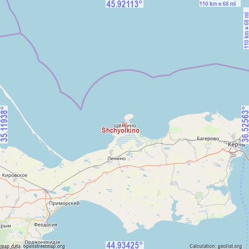
Shchyolkino GPS coordinates[2]
45° 25' 47.46" North, 35° 49' 21" East
| Map corner | latitude | longitude |
|---|---|---|
| Upper-left | 45.92113°, | 35.11938° |
| Center: | 45.42985°, | 35.8225° |
| Lower-right: | 44.93425°, | 36.52563° |
| Map W x H: | 109.7×109.7 km | = 68.2×68.2mi |
| max Lat: | 52.18903° ⇑79.1% North |
| Shchyolkino: | 45.42985° |
| min Lat: | ⇓20.9% South 44.39214° |
| min Long | Shchyolkino | max Long |
| 22.20555° | 35.8225° | 40.13222° |
| W 86%⇐ | ⇒14% E |
Elevation
Elevation of Shchyolkino is 3 m = 10 ft, and this is 152.8 m = 501 ft below average elevation for this country.
| Max E: |
886 m = 2907 ft | 99.5% |
| Avg. | 155.8 m = 511 ft | |
| Shchyolkino | 3 m = 10 ft | |
Min E: |
-3 m = -10 ft | 0.5% |
See also: Ukraine elevation on elevation.city.
Geographical zone
Shchyolkino is located in North temperate zone (between Tropic of Cancer and the Arctic Circle). Distance of this North polar circle is 2349.8 km =1460.1 mi to North.| Distance of | km | miles | from Shchyolkino |
|---|---|---|---|
| North Pole | 4955.7 | 3079.3 | to North |
| Arctic Circle | 2349.8 | 1460.1 | to North |
| Tropic Cancer | 2445.4 | 1519.5 | to South |
| Equator | 5051.3 | 3138.7 | to South |


Nearby cities:
15 places around Shchyolkino: (largest is in red/bold)
• Belinskoye
21.2 km =13.2 mi,  106°
106°
• Chistopolye
29.1 km =18.1 mi,  104°
104°
• Ilychyovo
17.5 km =10.9 mi,  201°
201°
• Kalinovka
13.9 km =8.6 mi,  205°
205°
• Kirovo
23.3 km =14.5 mi,  176°
176°
• Krasnogorka
20.6 km =12.8 mi, 183°
• Lenino
15 km =9.3 mi,  193°
193°
• Leninskoye
21 km =13 mi,  158°
158°
• Lugovoye
23.1 km =14.4 mi, 199°
• Mysovoe
2.2 km =1.4 mi,  26°
26°
• Novonikolayevka
22.8 km =14.2 mi,  126°
126°
• Ostanino
13.4 km =8.3 mi,  148°
148°
• Semisotka
28.6 km =17.8 mi,  224°
224°
• Uvarovo
22.3 km =13.9 mi, 213°
• Vinogradnoye
15.3 km =9.5 mi,  173°
173°
Sources, notices
• [Note1] Compared only with cities in Ukraine existing in our database
• [Src1] Map data: © OpenStreetMap contributors (CC-BY-SA)
• [Src2] Other city data from geonames.org with taken over terms of usage.
• [Src3] Geographical zone / Annual Mean Temperature by Robert A. Rohde @ Wikipedia
