Leninskoye geodata
Leninskoye (Republic of Crimea) is a seat of a third-order administrative division; located in Ukraine in Europe/Simferopol (GMT+3) time zone. With population of 1,671 people, there are 1178 cities with bigger population in this country. Compared to other cities in Ukraine, 84.1% of cities are located further ↑North; 86.7% of cities are located further ←West and 82.5% of cities have higher elevation than Leninskoye. Note1
Administrative division(s):
- Level 1: Republic of Crimea
- Level 2: Lenine Raion
- Level 3: Leninskoye sel'skoye poselenye


Leninskoye GPS coordinates[2]
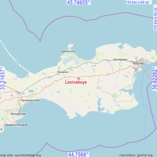
45° 15' 13.428" North, 35° 55' 10.884" East
| Map corner | latitude | longitude |
|---|---|---|
| Upper-left | 45.74655°, | 35.21657° |
| Center: | 45.25373°, | 35.91969° |
| Lower-right: | 44.7566°, | 36.62282° |
| Map W x H: | 110.1×110.1 km | = 68.4×68.4mi |
| max Lat: | 52.18903° ⇑84.1% North |
| Leninskoye: | 45.25373° |
| min Lat: | ⇓15.9% South 44.39214° |
| min Long | Leninskoye | max Long |
| 22.20555° | 35.91969° | 40.13222° |
| W 86.7%⇐ | ⇒13.3% E |
Elevation
Elevation of Leninskoye is 37 m = 121 ft, and this is 118.8 m = 390 ft below average elevation for this country.
| Max E: |
886 m = 2907 ft | 82.5% |
| Avg. | 155.8 m = 511 ft | |
| Leninskoye | 37 m = 121 ft | |
Min E: |
-3 m = -10 ft | 17.5% |
See also: Ukraine elevation on elevation.city.
Geographical zone
Leninskoye is located in North temperate zone (between Tropic of Cancer and the Arctic Circle). Distance of this North polar circle is 2369.4 km =1472.3 mi to North.| Distance of | km | miles | from Leninskoye |
|---|---|---|---|
| North Pole | 4975.3 | 3091.5 | to North |
| Arctic Circle | 2369.4 | 1472.3 | to North |
| Tropic Cancer | 2425.8 | 1507.3 | to South |
| Equator | 5031.7 | 3126.6 | to South |


Nearby cities:
15 places around Leninskoye: (largest is in red/bold)
• Belinskoye
18.5 km =11.5 mi,  43°
43°
• Gornostayevka
21 km =13 mi,  82°
82°
• Ilychyovo
14.5 km =9 mi,  283°
283°
• Kalinovka
15.2 km =9.4 mi,  297°
297°
• Kirovo
7.1 km =4.4 mi,  239°
239°
• Krasnogorka
8.8 km =5.5 mi,  263°
263°
• Lenino
12.2 km =7.6 mi,  294°
294°
• Lugovoye
15.6 km =9.7 mi, 262°
• Marfovka
14.8 km =9.2 mi,  114°
114°
• Mysovoe
22.6 km =14 mi,  343°
343°
• Novonikolayevka
12.4 km =7.7 mi,  60°
60°
• Ostanino
8.2 km =5.1 mi,  356°
356°
• Shchyolkino
21 km =13 mi, 338°
• Uvarovo
20 km =12.4 mi,  272°
272°
• Vinogradnoye
7.3 km =4.5 mi,  306°
306°
Sources, notices
• [Note1] Compared only with cities in Ukraine existing in our database
• [Src1] Map data: © OpenStreetMap contributors (CC-BY-SA)
• [Src2] Other city data from geonames.org with taken over terms of usage.
• [Src3] Geographical zone / Annual Mean Temperature by Robert A. Rohde @ Wikipedia
