Bayou La Batre geodata
Bayou La Batre (Alabama) is a populated place; located in United States in America/Chicago (GMT-5) time zone. With population of 2,621 people, there are 10348 cities with bigger population in this country. Compared to other cities in United States, 92.2% of cities are located further ↑North; 53.9% of cities are located further →East and 98.1% of cities have higher elevation than Bayou La Batre. Note1


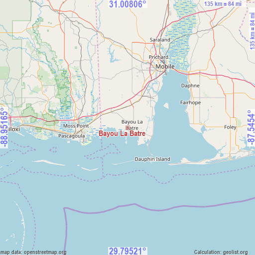
Bayou La Batre GPS coordinates[2]
30° 24' 12.672" North, 88° 14' 54.672" West
| Map corner | latitude | longitude |
|---|---|---|
| Upper-left | 31.00806°, | -88.95165° |
| Center: | 30.40352°, | -88.24852° |
| Lower-right: | 29.79521°, | -87.5454° |
| Map W x H: | 134.9×134.9 km | = 83.8×83.8mi |
| max Lat: | 71.29058° ⇑92.2% North |
| Bayou La Batre: | 30.40352° |
| min Lat: | ⇓7.8% South 19.06759° |
| min Long | Bayou La Batre | max Long |
| -171.73463° | -88.24852° | -66.98998° |
| W 46.1%⇐ | ⇒53.9% E |
Elevation
Elevation of Bayou La Batre is 5 m = 16 ft, and this is 289.8 m = 951 ft below average elevation for this country.
| Max E: |
3189 m = 10463 ft | 98.1% |
| Avg. | 294.8 m = 967 ft | |
| Bayou La Batre | 5 m = 16 ft | |
Min E: |
-60 m = -197 ft | 1.9% |
See also: United States elevation on elevation.city.
Geographical zone
Bayou La Batre is located in North temperate zone (between Tropic of Cancer and the Arctic Circle). Distance of this Northern Tropic circle is 774.6 km =481.3 mi to South.| Distance of | km | miles | from Bayou La Batre |
|---|---|---|---|
| North Pole | 6626.5 | 4117.5 | to North |
| Arctic Circle | 4020.6 | 2498.3 | to North |
| Tropic Cancer | 774.6 | 481.3 | to South |
| Equator | 3380.6 | 2100.6 | to South |


Nearby cities:
15 places around Bayou La Batre: (largest is in red/bold)
• Bellefontaine
17.1 km =10.6 mi,  54°
54°
• Big Point
30.3 km =18.8 mi,  312°
312°
• Dauphin Island
21.2 km =13.2 mi,  141°
141°
• Escatawpa
28.6 km =17.8 mi,  278°
278°
• Fairhope
35.6 km =22.1 mi,  68°
68°
• Gautier
34.9 km =21.7 mi,  266°
266°
• Grand Bay
12.1 km =7.5 mi, 312°
• Helena
25.8 km =16 mi,  293°
293°
• Hurley
37.1 km =23.1 mi,  320°
320°
• Mobile
37.9 km =23.5 mi,  31°
31°
• Moss Point
27.4 km =17 mi, 271°
• Pascagoula
29.8 km =18.5 mi,  261°
261°
• Point Clear
32.5 km =20.2 mi,  76°
76°
• Theodore
17.5 km =10.9 mi,  23°
23°
• Tillmans Corner
22 km =13.7 mi, 19°
Sources, notices
• [Note1] Compared only with cities in United States existing in our database
• [Src1] Map data: © OpenStreetMap contributors (CC-BY-SA)
• [Src2] Other city data from geonames.org with taken over terms of usage.
• [Src3] Geographical zone / Annual Mean Temperature by Robert A. Rohde @ Wikipedia
