Mobile geodata
Mobile (Alabama) is a seat of a second-order administrative division; located in United States in America/Chicago (GMT-5) time zone. With population of 194,288 people, there are 135 cities with bigger population in this country. Compared to other cities in United States, 91.3% of cities are located further ↑North; 53% of cities are located further →East and 92.1% of cities have higher elevation than Mobile. Note1


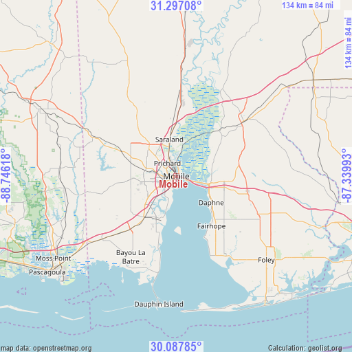
Mobile GPS coordinates[2]
30° 41' 39.696" North, 88° 2' 34.98" West
| Map corner | latitude | longitude |
|---|---|---|
| Upper-left | 31.29708°, | -88.74618° |
| Center: | 30.69436°, | -88.04305° |
| Lower-right: | 30.08785°, | -87.33993° |
| Map W x H: | 134.5×134.5 km | = 83.6×83.6mi |
| max Lat: | 71.29058° ⇑91.3% North |
| Mobile: | 30.69436° |
| min Lat: | ⇓8.7% South 19.06759° |
| min Long | Mobile | max Long |
| -171.73463° | -88.04305° | -66.98998° |
| W 47%⇐ | ⇒53% E |
Elevation
Elevation of Mobile is 12 m = 39 ft, and this is 282.8 m = 928 ft below average elevation for this country.
| Max E: |
3189 m = 10463 ft | 92.1% |
| Avg. | 294.8 m = 967 ft | |
| Mobile | 12 m = 39 ft | |
Min E: |
-60 m = -197 ft | 7.9% |
See also: Mobile elevation on elevation.city.
Geographical zone
Mobile is located in North temperate zone (between Tropic of Cancer and the Arctic Circle). Distance of this Northern Tropic circle is 807 km =501.4 mi to South.| Distance of | km | miles | from Mobile |
|---|---|---|---|
| North Pole | 6594.2 | 4097.4 | to North |
| Arctic Circle | 3988.3 | 2478.2 | to North |
| Tropic Cancer | 807 | 501.4 | to South |
| Equator | 3412.9 | 2120.7 | to South |


Nearby cities:
15 places around Mobile: (largest is in red/bold)
• Axis
26.2 km =16.3 mi,  3°
3°
• Bellefontaine
23.1 km =14.4 mi,  194°
194°
• Chickasaw
8.3 km =5.2 mi,  338°
338°
• Creola
22 km =13.7 mi, 0°
• Daphne
16.7 km =10.4 mi,  127°
127°
• Fairhope
23.3 km =14.5 mi,  144°
144°
• Loxley
29 km =18 mi,  106°
106°
• Point Clear
27.2 km =16.9 mi,  154°
154°
• Prichard
6 km =3.7 mi,  325°
325°
• Saraland
14.3 km =8.9 mi,  349°
349°
• Satsuma
17.7 km =11 mi,  355°
355°
• Semmes
22.7 km =14.1 mi,  294°
294°
• Spanish Fort
12.4 km =7.7 mi,  100°
100°
• Theodore
20.6 km =12.8 mi,  217°
217°
• Tillmans Corner
16.8 km =10.4 mi,  226°
226°
Sources, notices
• [Note1] Compared only with cities in United States existing in our database
• [Src1] Map data: © OpenStreetMap contributors (CC-BY-SA)
• [Src2] Other city data from geonames.org with taken over terms of usage.
• [Src3] Geographical zone / Annual Mean Temperature by Robert A. Rohde @ Wikipedia
