Cordova geodata
Cordova (Alabama) is a populated place; located in United States in America/Chicago (GMT-5) time zone. With population of 2,028 people, there are 11870 cities with bigger population in this country. Compared to other cities in United States, 81.7% of cities are located further ↑North; 50.1% of cities are located further →East and 70.6% of cities have higher elevation than Cordova. Note1


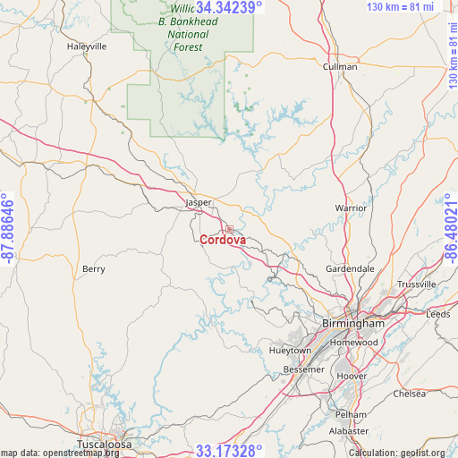
Cordova GPS coordinates[2]
33° 45' 35.388" North, 87° 10' 59.988" West
| Map corner | latitude | longitude |
|---|---|---|
| Upper-left | 34.34239°, | -87.88646° |
| Center: | 33.75983°, | -87.18333° |
| Lower-right: | 33.17328°, | -86.48021° |
| Map W x H: | 130×130 km | = 80.8×80.8mi |
| max Lat: | 71.29058° ⇑81.7% North |
| Cordova: | 33.75983° |
| min Lat: | ⇓18.3% South 19.06759° |
| min Long | Cordova | max Long |
| -171.73463° | -87.18333° | -66.98998° |
| W 49.9%⇐ | ⇒50.1% E |
Elevation
Elevation of Cordova is 97 m = 318 ft, and this is 197.8 m = 649 ft below average elevation for this country.
| Max E: |
3189 m = 10463 ft | 70.6% |
| Avg. | 294.8 m = 967 ft | |
| Cordova | 97 m = 318 ft | |
Min E: |
-60 m = -197 ft | 29.4% |
See also: United States elevation on elevation.city.
Geographical zone
Cordova is located in North temperate zone (between Tropic of Cancer and the Arctic Circle). Distance of this Northern Tropic circle is 1147.8 km =713.2 mi to South.| Distance of | km | miles | from Cordova |
|---|---|---|---|
| North Pole | 6253.3 | 3885.6 | to North |
| Arctic Circle | 3647.4 | 2266.4 | to North |
| Tropic Cancer | 1147.8 | 713.2 | to South |
| Equator | 3753.7 | 2332.4 | to South |


Nearby cities:
15 places around Cordova: (largest is in red/bold)
• Adamsville
27.5 km =17.1 mi,  130°
130°
• Brookside
28.1 km =17.5 mi,  118°
118°
• Dora
9.3 km =5.8 mi,  111°
111°
• Edgewater
33.3 km =20.7 mi,  141°
141°
• Forestdale
33.9 km =21.1 mi, 128°
• Graysville
25 km =15.5 mi, 128°
• Jasper
11.8 km =7.3 mi,  312°
312°
• Minor
33.4 km =20.8 mi, 137°
• Mount Olive
31.8 km =19.8 mi, 108°
• Mulga
30.3 km =18.8 mi, 140°
• Oakman
19.7 km =12.2 mi,  254°
254°
• Parrish
9.9 km =6.2 mi, 250°
• Rock Creek
32.9 km =20.4 mi,  163°
163°
• Sumiton
12.3 km =7.6 mi,  92°
92°
• Sylvan Springs
31.3 km =19.4 mi,  150°
150°
Sources, notices
• [Note1] Compared only with cities in United States existing in our database
• [Src1] Map data: © OpenStreetMap contributors (CC-BY-SA)
• [Src2] Other city data from geonames.org with taken over terms of usage.
• [Src3] Geographical zone / Annual Mean Temperature by Robert A. Rohde @ Wikipedia
