Graysville geodata
Graysville (Alabama) is a populated place; located in United States in America/Chicago (GMT-5) time zone. With population of 2,096 people, there are 11630 cities with bigger population in this country. Compared to other cities in United States, 82.5% of cities are located further ↑North; 50.3% of cities are located further ←West and 55.3% of cities have higher elevation than Graysville. Note1


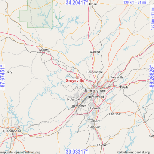
Graysville GPS coordinates[2]
33° 37' 14.376" North, 86° 58' 16.968" West
| Map corner | latitude | longitude |
|---|---|---|
| Upper-left | 34.20417°, | -87.67451° |
| Center: | 33.62066°, | -86.97138° |
| Lower-right: | 33.03317°, | -86.26826° |
| Map W x H: | 130.2×130.2 km | = 80.9×80.9mi |
| max Lat: | 71.29058° ⇑82.5% North |
| Graysville: | 33.62066° |
| min Lat: | ⇓17.5% South 19.06759° |
| min Long | Graysville | max Long |
| -171.73463° | -86.97138° | -66.98998° |
| W 50.3%⇐ | ⇒49.7% E |
Elevation
Elevation of Graysville is 179 m = 587 ft, and this is 115.8 m = 380 ft below average elevation for this country.
| Max E: |
3189 m = 10463 ft | 55.3% |
| Avg. | 294.8 m = 967 ft | |
| Graysville | 179 m = 587 ft | |
Min E: |
-60 m = -197 ft | 44.7% |
See also: United States elevation on elevation.city.
Geographical zone
Graysville is located in North temperate zone (between Tropic of Cancer and the Arctic Circle). Distance of this Northern Tropic circle is 1132.3 km =703.6 mi to South.| Distance of | km | miles | from Graysville |
|---|---|---|---|
| North Pole | 6268.8 | 3895.3 | to North |
| Arctic Circle | 3662.9 | 2276 | to North |
| Tropic Cancer | 1132.3 | 703.6 | to South |
| Equator | 3738.3 | 2322.9 | to South |


Nearby cities:
15 places around Graysville: (largest is in red/bold)
• Adamsville
2.6 km =1.6 mi,  147°
147°
• Brookside
5.4 km =3.4 mi,  69°
69°
• Dora
16.3 km =10.1 mi,  317°
317°
• Edgewater
10.5 km =6.5 mi,  173°
173°
• Fairfield
16 km =9.9 mi,  159°
159°
• Forestdale
8.9 km =5.5 mi,  128°
128°
• Fultondale
16.5 km =10.3 mi,  96°
96°
• Gardendale
15.3 km =9.5 mi, 73°
• McDonald Chapel
11.5 km =7.1 mi, 162°
• Minor
9.7 km =6 mi, 162°
• Mount Olive
12 km =7.5 mi,  62°
62°
• Mulga
7.9 km =4.9 mi,  181°
181°
• Pleasant Grove
14.4 km =8.9 mi, 179°
• Sumiton
16.7 km =10.4 mi,  334°
334°
• Sylvan Springs
12.4 km =7.7 mi,  199°
199°
Sources, notices
• [Note1] Compared only with cities in United States existing in our database
• [Src1] Map data: © OpenStreetMap contributors (CC-BY-SA)
• [Src2] Other city data from geonames.org with taken over terms of usage.
• [Src3] Geographical zone / Annual Mean Temperature by Robert A. Rohde @ Wikipedia
