Double Springs geodata
Double Springs (Alabama) is a seat of a second-order administrative division; located in United States in America/Chicago (GMT-5) time zone. With population of 1,056 people, there are 15920 cities with bigger population in this country. Compared to other cities in United States, 79.3% of cities are located further ↑North; 50.6% of cities are located further →East and 63.1% of cities have lower elevation than Double Springs. Note1


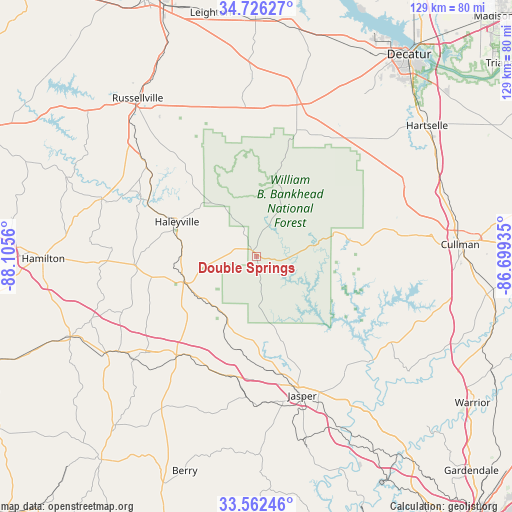
Double Springs GPS coordinates[2]
34° 8' 46.932" North, 87° 24' 8.892" West
| Map corner | latitude | longitude |
|---|---|---|
| Upper-left | 34.72627°, | -88.1056° |
| Center: | 34.14637°, | -87.40247° |
| Lower-right: | 33.56246°, | -86.69935° |
| Map W x H: | 129.4×129.4 km | = 80.4×80.4mi |
| max Lat: | 71.29058° ⇑79.3% North |
| Double Springs: | 34.14637° |
| min Lat: | ⇓20.7% South 19.06759° |
| min Long | Double Springs | max Long |
| -171.73463° | -87.40247° | -66.98998° |
| W 49.4%⇐ | ⇒50.6% E |
Elevation
Elevation of Double Springs is 253 m = 830 ft, and this is 41.8 m = 137 ft below average elevation for this country.
| Max E: |
3189 m = 10463 ft | 36.9% |
| Avg. | 294.8 m = 967 ft | |
| Double Springs | 253 m = 830 ft | |
Min E: |
-60 m = -197 ft | 63.1% |
See also: United States elevation on elevation.city.
Geographical zone
Double Springs is located in North temperate zone (between Tropic of Cancer and the Arctic Circle). Distance of this Northern Tropic circle is 1190.8 km =739.9 mi to South.| Distance of | km | miles | from Double Springs |
|---|---|---|---|
| North Pole | 6210.3 | 3858.9 | to North |
| Arctic Circle | 3604.5 | 2239.7 | to North |
| Tropic Cancer | 1190.8 | 739.9 | to South |
| Equator | 3796.7 | 2359.2 | to South |


Nearby cities:
15 places around Double Springs: (largest is in red/bold)
• Addison
21.3 km =13.2 mi,  72°
72°
• Bear Creek
30.9 km =19.2 mi,  297°
297°
• Brilliant
35.4 km =22 mi,  247°
247°
• Carbon Hill
30.5 km =19 mi,  201°
201°
• Cordova
47.5 km =29.5 mi,  154°
154°
• Danville
41.6 km =25.8 mi,  44°
44°
• Hackleburg
41.8 km =26 mi,  290°
290°
• Haleyville
22 km =13.7 mi, 293°
• Jasper
36.9 km =22.9 mi,  161°
161°
• Littleville
19.7 km =12.2 mi,  306°
306°
• Lynn
17.5 km =10.9 mi,  230°
230°
• Moulton
38.6 km =24 mi,  15°
15°
• Phil Campbell
36 km =22.4 mi, 309°
• West Point
42 km =26.1 mi,  75°
75°
• Winfield
45.2 km =28.1 mi,  237°
237°
Sources, notices
• [Note1] Compared only with cities in United States existing in our database
• [Src1] Map data: © OpenStreetMap contributors (CC-BY-SA)
• [Src2] Other city data from geonames.org with taken over terms of usage.
• [Src3] Geographical zone / Annual Mean Temperature by Robert A. Rohde @ Wikipedia
