Fultondale geodata
Fultondale (Alabama) is a populated place; located in United States in America/Chicago (GMT-5) time zone. With population of 9,048 people, there are 4784 cities with bigger population in this country. Compared to other cities in United States, 82.6% of cities are located further ↑North; 50.8% of cities are located further ←West and 50.5% of cities have higher elevation than Fultondale. Note1


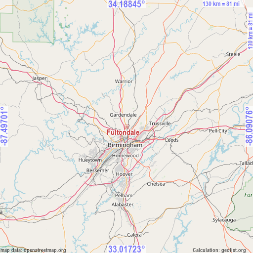
Fultondale GPS coordinates[2]
33° 36' 17.388" North, 86° 47' 37.968" West
| Map corner | latitude | longitude |
|---|---|---|
| Upper-left | 34.18845°, | -87.49701° |
| Center: | 33.60483°, | -86.79388° |
| Lower-right: | 33.01723°, | -86.09076° |
| Map W x H: | 130.2×130.2 km | = 80.9×80.9mi |
| max Lat: | 71.29058° ⇑82.6% North |
| Fultondale: | 33.60483° |
| min Lat: | ⇓17.4% South 19.06759° |
| min Long | Fultondale | max Long |
| -171.73463° | -86.79388° | -66.98998° |
| W 50.8%⇐ | ⇒49.2% E |
Elevation
Elevation of Fultondale is 196 m = 643 ft, and this is 98.8 m = 324 ft below average elevation for this country.
| Max E: |
3189 m = 10463 ft | 50.5% |
| Avg. | 294.8 m = 967 ft | |
| Fultondale | 196 m = 643 ft | |
Min E: |
-60 m = -197 ft | 49.5% |
See also: United States elevation on elevation.city.
Geographical zone
Fultondale is located in North temperate zone (between Tropic of Cancer and the Arctic Circle). Distance of this Northern Tropic circle is 1130.6 km =702.5 mi to South.| Distance of | km | miles | from Fultondale |
|---|---|---|---|
| North Pole | 6270.6 | 3896.4 | to North |
| Arctic Circle | 3664.7 | 2277.1 | to North |
| Tropic Cancer | 1130.6 | 702.5 | to South |
| Equator | 3736.5 | 2321.8 | to South |


Nearby cities:
15 places around Fultondale: (largest is in red/bold)
• Adamsville
15 km =9.3 mi,  268°
268°
• Birmingham
9.4 km =5.8 mi,  184°
184°
• Brookside
11.9 km =7.4 mi,  287°
287°
• Center Point
11.2 km =7 mi,  66°
66°
• Chalkville
14.6 km =9.1 mi, 68°
• Forestdale
10.2 km =6.3 mi,  247°
247°
• Gardendale
6.4 km =4 mi,  344°
344°
• Grayson Valley
15.1 km =9.4 mi, 71°
• Hollywood
14.7 km =9.1 mi, 176°
• Homewood
14.8 km =9.2 mi, 182°
• Irondale
10.9 km =6.8 mi,  132°
132°
• Mount Olive
9.3 km =5.8 mi,  321°
321°
• Mountain Brook
12.2 km =7.6 mi,  161°
161°
• Pinson
13.9 km =8.6 mi,  47°
47°
• Tarrant
3.1 km =1.9 mi,  140°
140°
Sources, notices
• [Note1] Compared only with cities in United States existing in our database
• [Src1] Map data: © OpenStreetMap contributors (CC-BY-SA)
• [Src2] Other city data from geonames.org with taken over terms of usage.
• [Src3] Geographical zone / Annual Mean Temperature by Robert A. Rohde @ Wikipedia
