Gardendale geodata
Gardendale (Alabama) is a populated place; located in United States in America/Chicago (GMT-5) time zone. With population of 13,711 people, there are 3502 cities with bigger population in this country. Compared to other cities in United States, 82.3% of cities are located further ↑North; 50.7% of cities are located further ←West and 52.2% of cities have lower elevation than Gardendale. Note1


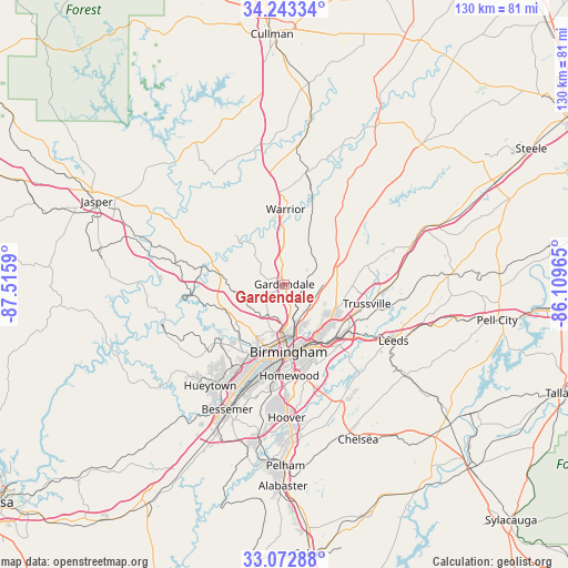
Gardendale GPS coordinates[2]
33° 39' 36.36" North, 86° 48' 45.972" West
| Map corner | latitude | longitude |
|---|---|---|
| Upper-left | 34.24334°, | -87.5159° |
| Center: | 33.6601°, | -86.81277° |
| Lower-right: | 33.07288°, | -86.10965° |
| Map W x H: | 130.1×130.1 km | = 80.8×80.8mi |
| max Lat: | 71.29058° ⇑82.3% North |
| Gardendale: | 33.6601° |
| min Lat: | ⇓17.7% South 19.06759° |
| min Long | Gardendale | max Long |
| -171.73463° | -86.81277° | -66.98998° |
| W 50.7%⇐ | ⇒49.3% E |
Elevation
Elevation of Gardendale is 207 m = 679 ft, and this is 87.8 m = 288 ft below average elevation for this country.
| Max E: |
3189 m = 10463 ft | 47.8% |
| Avg. | 294.8 m = 967 ft | |
| Gardendale | 207 m = 679 ft | |
Min E: |
-60 m = -197 ft | 52.2% |
See also: United States elevation on elevation.city.
Geographical zone
Gardendale is located in North temperate zone (between Tropic of Cancer and the Arctic Circle). Distance of this Northern Tropic circle is 1136.7 km =706.3 mi to South.| Distance of | km | miles | from Gardendale |
|---|---|---|---|
| North Pole | 6264.4 | 3892.5 | to North |
| Arctic Circle | 3658.5 | 2273.3 | to North |
| Tropic Cancer | 1136.7 | 706.3 | to South |
| Equator | 3742.7 | 2325.6 | to South |


Nearby cities:
15 places around Gardendale: (largest is in red/bold)
• Adamsville
14.8 km =9.2 mi,  243°
243°
• Birmingham
15.5 km =9.6 mi,  176°
176°
• Brookside
9.9 km =6.2 mi,  255°
255°
• Center Point
12.1 km =7.5 mi,  97°
97°
• Chalkville
15.3 km =9.5 mi,  92°
92°
• Forestdale
12.7 km =7.9 mi,  217°
217°
• Fultondale
6.4 km =4 mi,  164°
164°
• Grayson Valley
16.1 km =10 mi, 94°
• Graysville
15.3 km =9.5 mi,  253°
253°
• Irondale
16.7 km =10.4 mi,  144°
144°
• Kimberly
12.6 km =7.8 mi,  359°
359°
• Morris
9.8 km =6.1 mi,  2°
2°
• Mount Olive
4.2 km =2.6 mi,  286°
286°
• Pinson
12.4 km =7.7 mi,  74°
74°
• Tarrant
9.3 km =5.8 mi, 156°
Sources, notices
• [Note1] Compared only with cities in United States existing in our database
• [Src1] Map data: © OpenStreetMap contributors (CC-BY-SA)
• [Src2] Other city data from geonames.org with taken over terms of usage.
• [Src3] Geographical zone / Annual Mean Temperature by Robert A. Rohde @ Wikipedia
