Gulf Shores geodata
Gulf Shores (Alabama) is a populated place; located in United States in America/Chicago (GMT-5) time zone. With population of 11,131 people, there are 4146 cities with bigger population in this country. Compared to other cities in United States, 92.6% of cities are located further ↑North; 51.5% of cities are located further →East and 97.4% of cities have higher elevation than Gulf Shores. Note1


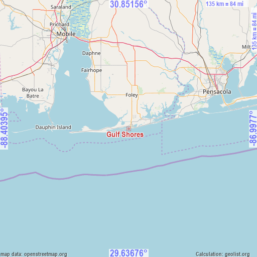
Gulf Shores GPS coordinates[2]
30° 14' 45.744" North, 87° 42' 2.952" West
| Map corner | latitude | longitude |
|---|---|---|
| Upper-left | 30.85156°, | -88.40395° |
| Center: | 30.24604°, | -87.70082° |
| Lower-right: | 29.63676°, | -86.9977° |
| Map W x H: | 135.1×135.1 km | = 83.9×83.9mi |
| max Lat: | 71.29058° ⇑92.6% North |
| Gulf Shores: | 30.24604° |
| min Lat: | ⇓7.4% South 19.06759° |
| min Long | Gulf Shores | max Long |
| -171.73463° | -87.70082° | -66.98998° |
| W 48.5%⇐ | ⇒51.5% E |
Elevation
Elevation of Gulf Shores is 6 m = 20 ft, and this is 288.8 m = 948 ft below average elevation for this country.
| Max E: |
3189 m = 10463 ft | 97.4% |
| Avg. | 294.8 m = 967 ft | |
| Gulf Shores | 6 m = 20 ft | |
Min E: |
-60 m = -197 ft | 2.6% |
See also: United States elevation on elevation.city.
Geographical zone
Gulf Shores is located in North temperate zone (between Tropic of Cancer and the Arctic Circle). Distance of this Northern Tropic circle is 757.1 km =470.4 mi to South.| Distance of | km | miles | from Gulf Shores |
|---|---|---|---|
| North Pole | 6644 | 4128.4 | to North |
| Arctic Circle | 4038.1 | 2509.2 | to North |
| Tropic Cancer | 757.1 | 470.4 | to South |
| Equator | 3363 | 2089.7 | to South |


Nearby cities:
15 places around Gulf Shores: (largest is in red/bold)
• Bellview
44.1 km =27.4 mi,  57°
57°
• Dauphin Island
39.3 km =24.4 mi,  271°
271°
• Elberta
21.2 km =13.2 mi,  27°
27°
• Fairhope
36.4 km =22.6 mi,  327°
327°
• Foley
17.9 km =11.1 mi,  5°
5°
• Loxley
41.7 km =25.9 mi,  353°
353°
• Magnolia Springs
18.5 km =11.5 mi,  337°
337°
• Myrtle Grove
42.5 km =26.4 mi, 62°
• Orange Beach
13.3 km =8.3 mi,  66°
66°
• Perdido Beach
21.6 km =13.4 mi, 60°
• Point Clear
32.9 km =20.4 mi,  320°
320°
• Robertsdale
34.2 km =21.3 mi,  358°
358°
• Silverhill
33.6 km =20.9 mi, 351°
• Summerdale
26.9 km =16.7 mi,  0°
0°
• Warrington
43.7 km =27.2 mi, 69°
Sources, notices
• [Note1] Compared only with cities in United States existing in our database
• [Src1] Map data: © OpenStreetMap contributors (CC-BY-SA)
• [Src2] Other city data from geonames.org with taken over terms of usage.
• [Src3] Geographical zone / Annual Mean Temperature by Robert A. Rohde @ Wikipedia
