Robertsdale geodata
Robertsdale (Alabama) is a populated place; located in United States in America/Chicago (GMT-5) time zone. With population of 5,894 people, there are 6477 cities with bigger population in this country. Compared to other cities in United States, 91.6% of cities are located further ↑North; 51.6% of cities are located further →East and 79.5% of cities have higher elevation than Robertsdale. Note1


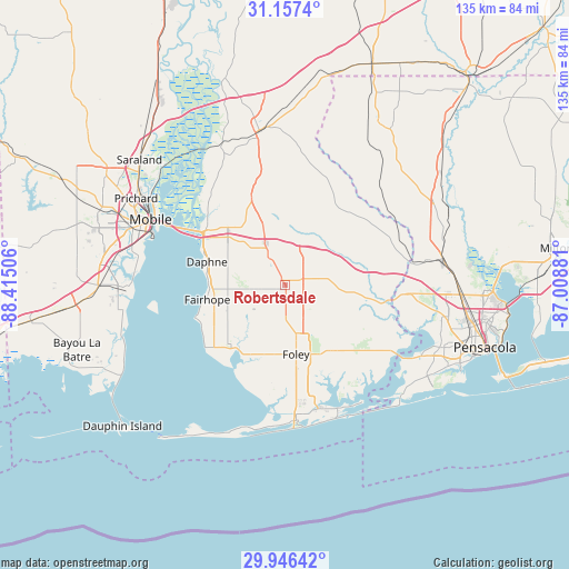
Robertsdale GPS coordinates[2]
30° 33' 13.68" North, 87° 42' 42.948" West
| Map corner | latitude | longitude |
|---|---|---|
| Upper-left | 31.1574°, | -88.41506° |
| Center: | 30.5538°, | -87.71193° |
| Lower-right: | 29.94642°, | -87.00881° |
| Map W x H: | 134.6×134.6 km | = 83.6×83.6mi |
| max Lat: | 71.29058° ⇑91.6% North |
| Robertsdale: | 30.5538° |
| min Lat: | ⇓8.4% South 19.06759° |
| min Long | Robertsdale | max Long |
| -171.73463° | -87.71193° | -66.98998° |
| W 48.4%⇐ | ⇒51.6% E |
Elevation
Elevation of Robertsdale is 49 m = 161 ft, and this is 245.8 m = 806 ft below average elevation for this country.
| Max E: |
3189 m = 10463 ft | 79.5% |
| Avg. | 294.8 m = 967 ft | |
| Robertsdale | 49 m = 161 ft | |
Min E: |
-60 m = -197 ft | 20.5% |
See also: United States elevation on elevation.city.
Geographical zone
Robertsdale is located in North temperate zone (between Tropic of Cancer and the Arctic Circle). Distance of this Northern Tropic circle is 791.3 km =491.7 mi to South.| Distance of | km | miles | from Robertsdale |
|---|---|---|---|
| North Pole | 6609.8 | 4107.1 | to North |
| Arctic Circle | 4003.9 | 2487.9 | to North |
| Tropic Cancer | 791.3 | 491.7 | to South |
| Equator | 3397.3 | 2111 | to South |


Nearby cities:
15 places around Robertsdale: (largest is in red/bold)
• Cantonment
36.1 km =22.4 mi,  80°
80°
• Daphne
19.2 km =11.9 mi,  286°
286°
• Elberta
19 km =11.8 mi,  144°
144°
• Fairhope
18.6 km =11.6 mi,  259°
259°
• Foley
16.6 km =10.3 mi,  170°
170°
• Gulf Shores
34.2 km =21.3 mi,  178°
178°
• Loxley
8.2 km =5.1 mi,  331°
331°
• Magnolia Springs
18.2 km =11.3 mi,  199°
199°
• Mobile
35.3 km =21.9 mi,  296°
296°
• Orange Beach
31.7 km =19.7 mi,  155°
155°
• Perdido Beach
30.9 km =19.2 mi, 140°
• Point Clear
21.7 km =13.5 mi,  245°
245°
• Silverhill
3.9 km =2.4 mi, 256°
• Spanish Fort
23.7 km =14.7 mi, 304°
• Summerdale
7.4 km =4.6 mi, 170°
Sources, notices
• [Note1] Compared only with cities in United States existing in our database
• [Src1] Map data: © OpenStreetMap contributors (CC-BY-SA)
• [Src2] Other city data from geonames.org with taken over terms of usage.
• [Src3] Geographical zone / Annual Mean Temperature by Robert A. Rohde @ Wikipedia
