Moody geodata
Moody (Alabama) is a populated place; located in United States in America/Chicago (GMT-5) time zone. With population of 12,593 people, there are 3756 cities with bigger population in this country. Compared to other cities in United States, 82.7% of cities are located further ↑North; 51.6% of cities are located further ←West and 53% of cities have lower elevation than Moody. Note1


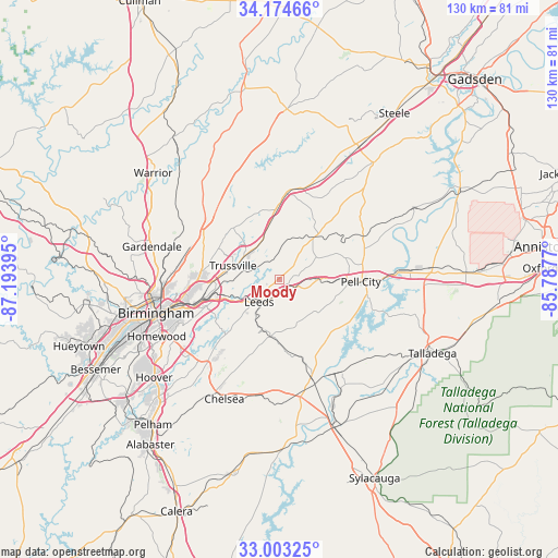
Moody GPS coordinates[2]
33° 35' 27.384" North, 86° 29' 26.952" West
| Map corner | latitude | longitude |
|---|---|---|
| Upper-left | 34.17466°, | -87.19395° |
| Center: | 33.59094°, | -86.49082° |
| Lower-right: | 33.00325°, | -85.7877° |
| Map W x H: | 130.2×130.2 km | = 80.9×80.9mi |
| max Lat: | 71.29058° ⇑82.7% North |
| Moody: | 33.59094° |
| min Lat: | ⇓17.3% South 19.06759° |
| min Long | Moody | max Long |
| -171.73463° | -86.49082° | -66.98998° |
| W 51.6%⇐ | ⇒48.4% E |
Elevation
Elevation of Moody is 210 m = 689 ft, and this is 84.8 m = 278 ft below average elevation for this country.
| Max E: |
3189 m = 10463 ft | 47% |
| Avg. | 294.8 m = 967 ft | |
| Moody | 210 m = 689 ft | |
Min E: |
-60 m = -197 ft | 53% |
See also: United States elevation on elevation.city.
Geographical zone
Moody is located in North temperate zone (between Tropic of Cancer and the Arctic Circle). Distance of this Northern Tropic circle is 1129 km =701.5 mi to South.| Distance of | km | miles | from Moody |
|---|---|---|---|
| North Pole | 6272.1 | 3897.3 | to North |
| Arctic Circle | 3666.2 | 2278.1 | to North |
| Tropic Cancer | 1129 | 701.5 | to South |
| Equator | 3735 | 2320.8 | to South |


Nearby cities:
15 places around Moody: (largest is in red/bold)
• Argo
10.8 km =6.7 mi,  355°
355°
• Branchville
14.8 km =9.2 mi,  34°
34°
• Center Point
18.9 km =11.7 mi,  288°
288°
• Chalkville
16.1 km =10 mi,  295°
295°
• Clay
16 km =9.9 mi,  320°
320°
• Dunnavant
11.9 km =7.4 mi,  204°
204°
• Grayson Valley
15.2 km =9.4 mi, 294°
• Leeds
6.9 km =4.3 mi,  226°
226°
• Margaret
10.7 km =6.6 mi,  7°
7°
• Odenville
13 km =8.1 mi,  42°
42°
• Pell City
19 km =11.8 mi,  91°
91°
• Springville
20.5 km =12.7 mi,  4°
4°
• Sterrett
15.8 km =9.8 mi,  176°
176°
• Trussville
11.4 km =7.1 mi, 286°
• Vandiver
13.5 km =8.4 mi,  188°
188°
Sources, notices
• [Note1] Compared only with cities in United States existing in our database
• [Src1] Map data: © OpenStreetMap contributors (CC-BY-SA)
• [Src2] Other city data from geonames.org with taken over terms of usage.
• [Src3] Geographical zone / Annual Mean Temperature by Robert A. Rohde @ Wikipedia
