Leeds geodata
Leeds (Alabama) is a populated place; located in United States in America/Chicago (GMT-5) time zone. With population of 11,936 people, there are 3917 cities with bigger population in this country. Compared to other cities in United States, 82.9% of cities are located further ↑North; 51.4% of cities are located further ←West and 51.9% of cities have higher elevation than Leeds. Note1


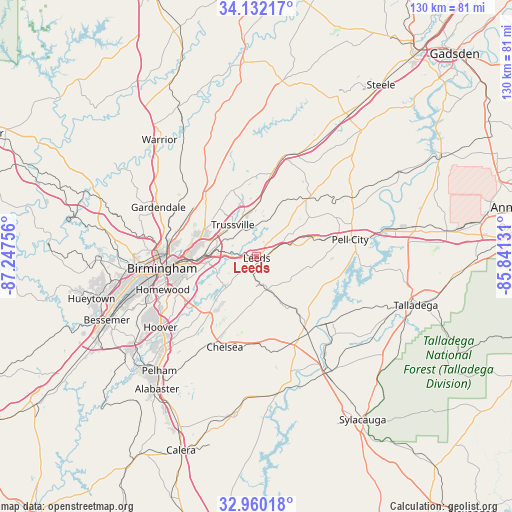
Leeds GPS coordinates[2]
33° 32' 53.376" North, 86° 32' 39.948" West
| Map corner | latitude | longitude |
|---|---|---|
| Upper-left | 34.13217°, | -87.24756° |
| Center: | 33.54816°, | -86.54443° |
| Lower-right: | 32.96018°, | -85.84131° |
| Map W x H: | 130.3×130.3 km | = 81×81mi |
| max Lat: | 71.29058° ⇑82.9% North |
| Leeds: | 33.54816° |
| min Lat: | ⇓17.1% South 19.06759° |
| min Long | Leeds | max Long |
| -171.73463° | -86.54443° | -66.98998° |
| W 51.4%⇐ | ⇒48.6% E |
Elevation
Elevation of Leeds is 191 m = 627 ft, and this is 103.8 m = 341 ft below average elevation for this country.
| Max E: |
3189 m = 10463 ft | 51.9% |
| Avg. | 294.8 m = 967 ft | |
| Leeds | 191 m = 627 ft | |
Min E: |
-60 m = -197 ft | 48.1% |
See also: United States elevation on elevation.city.
Geographical zone
Leeds is located in North temperate zone (between Tropic of Cancer and the Arctic Circle). Distance of this Northern Tropic circle is 1124.3 km =698.6 mi to South.| Distance of | km | miles | from Leeds |
|---|---|---|---|
| North Pole | 6276.9 | 3900.3 | to North |
| Arctic Circle | 3671 | 2281.1 | to North |
| Tropic Cancer | 1124.3 | 698.6 | to South |
| Equator | 3730.2 | 2317.8 | to South |


Nearby cities:
15 places around Leeds: (largest is in red/bold)
• Argo
16 km =9.9 mi,  14°
14°
• Brook Highland
17.3 km =10.7 mi,  223°
223°
• Center Point
16.8 km =10.4 mi,  310°
310°
• Chalkville
15.1 km =9.4 mi,  320°
320°
• Clay
17.9 km =11.1 mi,  343°
343°
• Dunnavant
6.1 km =3.8 mi,  179°
179°
• Grayson Valley
14.2 km =8.8 mi, 321°
• Irondale
15.1 km =9.4 mi,  265°
265°
• Lake Purdy
18.2 km =11.3 mi, 223°
• Margaret
16.6 km =10.3 mi,  22°
22°
• Moody
6.9 km =4.3 mi,  46°
46°
• Shoal Creek
14.4 km =8.9 mi,  205°
205°
• Sterrett
12.6 km =7.8 mi,  151°
151°
• Trussville
10 km =6.2 mi, 323°
• Vandiver
9.1 km =5.7 mi,  161°
161°
Sources, notices
• [Note1] Compared only with cities in United States existing in our database
• [Src1] Map data: © OpenStreetMap contributors (CC-BY-SA)
• [Src2] Other city data from geonames.org with taken over terms of usage.
• [Src3] Geographical zone / Annual Mean Temperature by Robert A. Rohde @ Wikipedia
