Sylvania geodata
Sylvania (Alabama) is a populated place; located in United States in America/Chicago (GMT-5) time zone. With population of 1,854 people, there are 12358 cities with bigger population in this country. Compared to other cities in United States, 77.4% of cities are located further ↑North; 53.4% of cities are located further ←West and 84.9% of cities have lower elevation than Sylvania. Note1


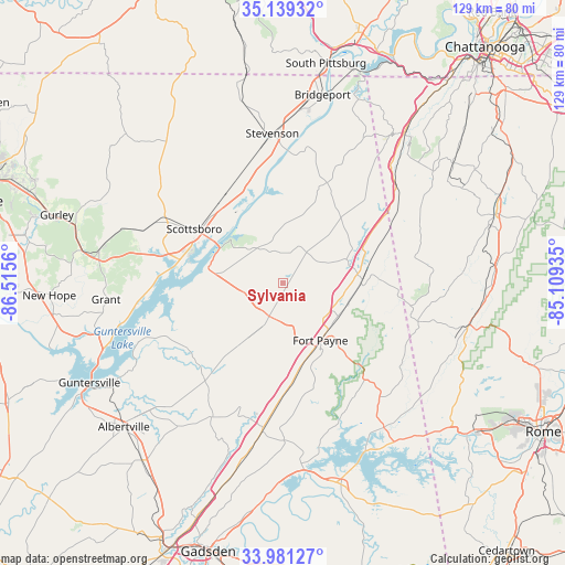
Sylvania GPS coordinates[2]
34° 33' 44.316" North, 85° 48' 44.892" West
| Map corner | latitude | longitude |
|---|---|---|
| Upper-left | 35.13932°, | -86.5156° |
| Center: | 34.56231°, | -85.81247° |
| Lower-right: | 33.98127°, | -85.10935° |
| Map W x H: | 128.8×128.8 km | = 80×80mi |
| max Lat: | 71.29058° ⇑77.4% North |
| Sylvania: | 34.56231° |
| min Lat: | ⇓22.6% South 19.06759° |
| min Long | Sylvania | max Long |
| -171.73463° | -85.81247° | -66.98998° |
| W 53.4%⇐ | ⇒46.6% E |
Elevation
Elevation of Sylvania is 421 m = 1381 ft, and this is 126.2 m = 414 ft above average elevation for this country.
| Max E: |
3189 m = 10463 ft | 15.1% |
| Sylvania | 421 m 1381 ft | |
| Avg. | 294.8 m = 967 ft | |
Min E: |
-60 m = -197 ft | 84.9% |
See also: United States elevation on elevation.city.
Geographical zone
Sylvania is located in North temperate zone (between Tropic of Cancer and the Arctic Circle). Distance of this Northern Tropic circle is 1237 km =768.6 mi to South.| Distance of | km | miles | from Sylvania |
|---|---|---|---|
| North Pole | 6164.1 | 3830.2 | to North |
| Arctic Circle | 3558.2 | 2211 | to North |
| Tropic Cancer | 1237 | 768.6 | to South |
| Equator | 3843 | 2387.9 | to South |


Nearby cities:
15 places around Sylvania: (largest is in red/bold)
• Collinsville
33.5 km =20.8 mi,  187°
187°
• Fort Payne
15.6 km =9.7 mi,  147°
147°
• Fyffe
15.4 km =9.6 mi,  213°
213°
• Geraldine
29.1 km =18.1 mi,  216°
216°
• Henagar
9.1 km =5.7 mi,  27°
27°
• Hollywood
23.2 km =14.4 mi,  320°
320°
• Ider
20.7 km =12.9 mi,  35°
35°
• Mount Vernon
30.1 km =18.7 mi,  175°
175°
• Pisgah
13.6 km =8.5 mi,  346°
346°
• Powell
8.2 km =5.1 mi,  245°
245°
• Rainsville
8.2 km =5.1 mi,  203°
203°
• Scottsboro
23.7 km =14.7 mi,  301°
301°
• Section
16.1 km =10 mi,  276°
276°
• Stevenson
34.2 km =21.3 mi,  355°
355°
• Valley Head
18.1 km =11.2 mi,  87°
87°
Sources, notices
• [Note1] Compared only with cities in United States existing in our database
• [Src1] Map data: © OpenStreetMap contributors (CC-BY-SA)
• [Src2] Other city data from geonames.org with taken over terms of usage.
• [Src3] Geographical zone / Annual Mean Temperature by Robert A. Rohde @ Wikipedia
