Fort Payne geodata
Fort Payne (Alabama) is a seat of a second-order administrative division; located in United States in America/Chicago (GMT-5) time zone. With population of 14,150 people, there are 3400 cities with bigger population in this country. Compared to other cities in United States, 77.9% of cities are located further ↑North; 53.7% of cities are located further ←West and 68.5% of cities have lower elevation than Fort Payne. Note1


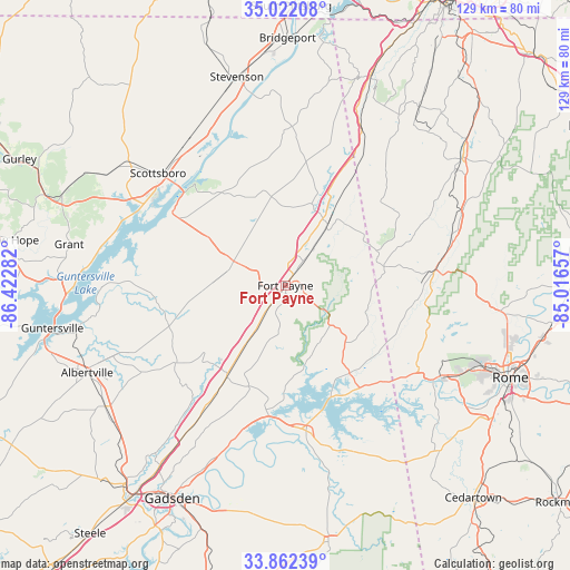
Fort Payne GPS coordinates[2]
34° 26' 39.3" North, 85° 43' 10.884" West
| Map corner | latitude | longitude |
|---|---|---|
| Upper-left | 35.02208°, | -86.42282° |
| Center: | 34.44425°, | -85.71969° |
| Lower-right: | 33.86239°, | -85.01657° |
| Map W x H: | 128.9×128.9 km | = 80.1×80.1mi |
| max Lat: | 71.29058° ⇑77.9% North |
| Fort Payne: | 34.44425° |
| min Lat: | ⇓22.1% South 19.06759° |
| min Long | Fort Payne | max Long |
| -171.73463° | -85.71969° | -66.98998° |
| W 53.7%⇐ | ⇒46.3% E |
Elevation
Elevation of Fort Payne is 278 m = 912 ft, and this is 16.8 m = 55 ft below average elevation for this country.
| Max E: |
3189 m = 10463 ft | 31.5% |
| Avg. | 294.8 m = 967 ft | |
| Fort Payne | 278 m = 912 ft | |
Min E: |
-60 m = -197 ft | 68.5% |
See also: United States elevation on elevation.city.
Geographical zone
Fort Payne is located in North temperate zone (between Tropic of Cancer and the Arctic Circle). Distance of this Northern Tropic circle is 1223.9 km =760.5 mi to South.| Distance of | km | miles | from Fort Payne |
|---|---|---|---|
| North Pole | 6177.2 | 3838.3 | to North |
| Arctic Circle | 3571.3 | 2219.1 | to North |
| Tropic Cancer | 1223.9 | 760.5 | to South |
| Equator | 3829.8 | 2379.7 | to South |


Nearby cities:
15 places around Fort Payne: (largest is in red/bold)
• Cedar Bluff
27 km =16.8 mi,  157°
157°
• Collinsville
23.9 km =14.9 mi,  212°
212°
• Fyffe
16.9 km =10.5 mi,  270°
270°
• Geraldine
27.8 km =17.3 mi,  248°
248°
• Henagar
21.7 km =13.5 mi,  348°
348°
• Leesburg
29.6 km =18.4 mi,  187°
187°
• Lyerly
29.4 km =18.3 mi,  98°
98°
• Mount Vernon
18 km =11.2 mi,  200°
200°
• Pisgah
28.8 km =17.9 mi,  335°
335°
• Powell
18.8 km =11.7 mi,  301°
301°
• Rainsville
13 km =8.1 mi, 295°
• Sand Rock
22.8 km =14.2 mi, 191°
• Section
28.7 km =17.8 mi, 301°
• Sylvania
15.6 km =9.7 mi,  327°
327°
• Valley Head
16.9 km =10.5 mi,  34°
34°
Sources, notices
• [Note1] Compared only with cities in United States existing in our database
• [Src1] Map data: © OpenStreetMap contributors (CC-BY-SA)
• [Src2] Other city data from geonames.org with taken over terms of usage.
• [Src3] Geographical zone / Annual Mean Temperature by Robert A. Rohde @ Wikipedia
