Amity geodata
Amity (Arkansas) is a populated place; located in United States in America/Chicago (GMT-5) time zone. With population of 702 people, there are 18655 cities with bigger population in this country. Compared to other cities in United States, 78.6% of cities are located further ↑North; 67.4% of cities are located further →East and 59.3% of cities have higher elevation than Amity. Note1


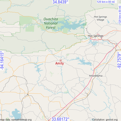
Amity GPS coordinates[2]
34° 15' 53.352" North, 93° 27' 39.672" West
| Map corner | latitude | longitude |
|---|---|---|
| Upper-left | 34.8439°, | -94.16415° |
| Center: | 34.26482°, | -93.46102° |
| Lower-right: | 33.68172°, | -92.7579° |
| Map W x H: | 129.2×129.2 km | = 80.3×80.3mi |
| max Lat: | 71.29058° ⇑78.6% North |
| Amity: | 34.26482° |
| min Lat: | ⇓21.4% South 19.06759° |
| min Long | Amity | max Long |
| -171.73463° | -93.46102° | -66.98998° |
| W 32.6%⇐ | ⇒67.4% E |
Elevation
Elevation of Amity is 158 m = 518 ft, and this is 136.8 m = 449 ft below average elevation for this country.
| Max E: |
3189 m = 10463 ft | 59.3% |
| Avg. | 294.8 m = 967 ft | |
| Amity | 158 m = 518 ft | |
Min E: |
-60 m = -197 ft | 40.7% |
See also: United States elevation on elevation.city.
Geographical zone
Amity is located in North temperate zone (between Tropic of Cancer and the Arctic Circle). Distance of this Northern Tropic circle is 1204 km =748.1 mi to South.| Distance of | km | miles | from Amity |
|---|---|---|---|
| North Pole | 6197.2 | 3850.8 | to North |
| Arctic Circle | 3591.3 | 2231.5 | to North |
| Tropic Cancer | 1204 | 748.1 | to South |
| Equator | 3809.9 | 2367.4 | to South |


Nearby cities:
15 places around Amity: (largest is in red/bold)
• Arkadelphia
40.7 km =25.3 mi,  113°
113°
• Caddo Valley
37 km =23 mi,  104°
104°
• Glenwood
10.7 km =6.6 mi,  309°
309°
• Gurdon
47.5 km =29.5 mi,  143°
143°
• Hot Springs
45.7 km =28.4 mi,  54°
54°
• Hot Springs National Park
47 km =29.2 mi, 50°
• Kirby
16.6 km =10.3 mi,  264°
264°
• Lake Hamilton
38 km =23.6 mi,  62°
62°
• Mount Ida
36.1 km =22.4 mi,  333°
333°
• Mountain Pine
43.2 km =26.8 mi,  37°
37°
• Murfreesboro
30.8 km =19.1 mi,  223°
223°
• Nashville
50.2 km =31.2 mi,  225°
225°
• Piney
40.6 km =25.2 mi, 49°
• Prescott
51.9 km =32.2 mi,  171°
171°
• Rockwell
37.3 km =23.2 mi, 53°
Sources, notices
• [Note1] Compared only with cities in United States existing in our database
• [Src1] Map data: © OpenStreetMap contributors (CC-BY-SA)
• [Src2] Other city data from geonames.org with taken over terms of usage.
• [Src3] Geographical zone / Annual Mean Temperature by Robert A. Rohde @ Wikipedia
