Austin geodata
Austin (Arkansas) is a populated place; located in United States in America/Chicago (GMT-5) time zone. With population of 3,383 people, there are 9015 cities with bigger population in this country. Compared to other cities in United States, 75.4% of cities are located further ↑North; 64.1% of cities are located further →East and 73.5% of cities have higher elevation than Austin. Note1


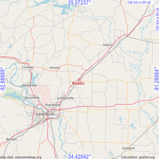
Austin GPS coordinates[2]
34° 59' 54.312" North, 91° 59' 1.536" West
| Map corner | latitude | longitude |
|---|---|---|
| Upper-left | 35.57237°, | -92.68689° |
| Center: | 34.99842°, | -91.98376° |
| Lower-right: | 34.42042°, | -91.28064° |
| Map W x H: | 128.1×128.1 km | = 79.6×79.6mi |
| max Lat: | 71.29058° ⇑75.4% North |
| Austin: | 34.99842° |
| min Lat: | ⇓24.6% South 19.06759° |
| min Long | Austin | max Long |
| -171.73463° | -91.98376° | -66.98998° |
| W 35.9%⇐ | ⇒64.1% E |
Elevation
Elevation of Austin is 80 m = 262 ft, and this is 214.8 m = 705 ft below average elevation for this country.
| Max E: |
3189 m = 10463 ft | 73.5% |
| Avg. | 294.8 m = 967 ft | |
| Austin | 80 m = 262 ft | |
Min E: |
-60 m = -197 ft | 26.5% |
See also: United States elevation on elevation.city.
Geographical zone
Austin is located in North temperate zone (between Tropic of Cancer and the Arctic Circle). Distance of this Northern Tropic circle is 1285.5 km =798.8 mi to South.| Distance of | km | miles | from Austin |
|---|---|---|---|
| North Pole | 6115.6 | 3800.1 | to North |
| Arctic Circle | 3509.7 | 2180.8 | to North |
| Tropic Cancer | 1285.5 | 798.8 | to South |
| Equator | 3891.5 | 2418.1 | to South |


Nearby cities:
15 places around Austin: (largest is in red/bold)
• Beebe
12.4 km =7.7 mi,  49°
49°
• Cabot
4 km =2.5 mi,  228°
228°
• Carlisle
32.3 km =20.1 mi,  137°
137°
• Gibson
26.2 km =16.3 mi,  241°
241°
• Gravel Ridge
23.8 km =14.8 mi, 232°
• Higginson
32.9 km =20.4 mi, 48°
• Holland
32.7 km =20.3 mi,  306°
306°
• Jacksonville
18.7 km =11.6 mi,  218°
218°
• Little Rock Air Force Base
20 km =12.4 mi, 233°
• Lonoke
25 km =15.5 mi,  162°
162°
• McAlmont
27.8 km =17.3 mi, 220°
• McRae
19.4 km =12.1 mi, 49°
• Sherwood
29.9 km =18.6 mi, 227°
• Vilonia
22.5 km =14 mi,  294°
294°
• Ward
4.7 km =2.9 mi,  40°
40°
Sources, notices
• [Note1] Compared only with cities in United States existing in our database
• [Src1] Map data: © OpenStreetMap contributors (CC-BY-SA)
• [Src2] Other city data from geonames.org with taken over terms of usage.
• [Src3] Geographical zone / Annual Mean Temperature by Robert A. Rohde @ Wikipedia
