Elaine geodata
Elaine (Arkansas) is a populated place; located in United States in America/Chicago (GMT-5) time zone. With population of 556 people, there are 20205 cities with bigger population in this country. Compared to other cities in United States, 78.4% of cities are located further ↑North; 61.8% of cities are located further →East and 79.5% of cities have higher elevation than Elaine. Note1


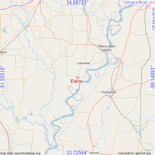
Elaine GPS coordinates[2]
34° 18' 30.384" North, 90° 51' 7.38" West
| Map corner | latitude | longitude |
|---|---|---|
| Upper-left | 34.88722°, | -91.55518° |
| Center: | 34.30844°, | -90.85205° |
| Lower-right: | 33.72564°, | -90.14893° |
| Map W x H: | 129.2×129.2 km | = 80.3×80.3mi |
| max Lat: | 71.29058° ⇑78.4% North |
| Elaine: | 34.30844° |
| min Lat: | ⇓21.6% South 19.06759° |
| min Long | Elaine | max Long |
| -171.73463° | -90.85205° | -66.98998° |
| W 38.2%⇐ | ⇒61.8% E |
Elevation
Elevation of Elaine is 49 m = 161 ft, and this is 245.8 m = 806 ft below average elevation for this country.
| Max E: |
3189 m = 10463 ft | 79.5% |
| Avg. | 294.8 m = 967 ft | |
| Elaine | 49 m = 161 ft | |
Min E: |
-60 m = -197 ft | 20.5% |
See also: United States elevation on elevation.city.
Geographical zone
Elaine is located in North temperate zone (between Tropic of Cancer and the Arctic Circle). Distance of this Northern Tropic circle is 1208.8 km =751.1 mi to South.| Distance of | km | miles | from Elaine |
|---|---|---|---|
| North Pole | 6192.3 | 3847.7 | to North |
| Arctic Circle | 3586.4 | 2228.5 | to North |
| Tropic Cancer | 1208.8 | 751.1 | to South |
| Equator | 3814.7 | 2370.3 | to South |


Nearby cities:
15 places around Elaine: (largest is in red/bold)
• Clarksdale
28.5 km =17.7 mi,  114°
114°
• De Witt
44.7 km =27.8 mi,  267°
267°
• Friars Point
20.8 km =12.9 mi,  70°
70°
• Gillett
52.7 km =32.7 mi,  246°
246°
• Helena
34.3 km =21.3 mi,  44°
44°
• Helena-West Helena
34.3 km =21.3 mi, 44°
• Holly Grove
45.2 km =28.1 mi,  315°
315°
• Jonestown
36.4 km =22.6 mi,  88°
88°
• Marianna
52.5 km =32.6 mi,  9°
9°
• Marvell
28 km =17.4 mi,  348°
348°
• Mound Bayou
49.2 km =30.6 mi,  166°
166°
• Shelby
40.5 km =25.2 mi, 168°
• Tutwiler
50.6 km =31.4 mi,  130°
130°
• Walnut
45.3 km =28.1 mi, 113°
• West Helena
33.1 km =20.6 mi, 35°
Sources, notices
• [Note1] Compared only with cities in United States existing in our database
• [Src1] Map data: © OpenStreetMap contributors (CC-BY-SA)
• [Src2] Other city data from geonames.org with taken over terms of usage.
• [Src3] Geographical zone / Annual Mean Temperature by Robert A. Rohde @ Wikipedia
