Ola geodata
Ola (Arkansas) is a populated place; located in United States in America/Chicago (GMT-5) time zone. With population of 1,250 people, there are 14854 cities with bigger population in this country. Compared to other cities in United States, 75.2% of cities are located further ↑North; 66.8% of cities are located further →East and 68.3% of cities have higher elevation than Ola. Note1


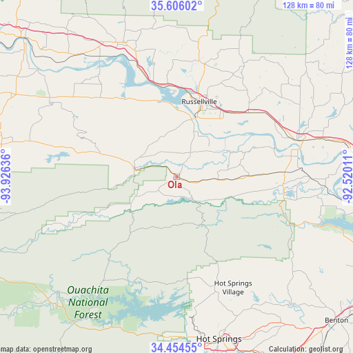
Ola GPS coordinates[2]
35° 1' 56.316" North, 93° 13' 23.628" West
| Map corner | latitude | longitude |
|---|---|---|
| Upper-left | 35.60602°, | -93.92636° |
| Center: | 35.03231°, | -93.22323° |
| Lower-right: | 34.45455°, | -92.52011° |
| Map W x H: | 128×128 km | = 79.5×79.5mi |
| max Lat: | 71.29058° ⇑75.2% North |
| Ola: | 35.03231° |
| min Lat: | ⇓24.8% South 19.06759° |
| min Long | Ola | max Long |
| -171.73463° | -93.22323° | -66.98998° |
| W 33.2%⇐ | ⇒66.8% E |
Elevation
Elevation of Ola is 111 m = 364 ft, and this is 183.8 m = 603 ft below average elevation for this country.
| Max E: |
3189 m = 10463 ft | 68.3% |
| Avg. | 294.8 m = 967 ft | |
| Ola | 111 m = 364 ft | |
Min E: |
-60 m = -197 ft | 31.7% |
See also: United States elevation on elevation.city.
Geographical zone
Ola is located in North temperate zone (between Tropic of Cancer and the Arctic Circle). Distance of this Northern Tropic circle is 1289.3 km =801.1 mi to South.| Distance of | km | miles | from Ola |
|---|---|---|---|
| North Pole | 6111.8 | 3797.7 | to North |
| Arctic Circle | 3505.9 | 2178.5 | to North |
| Tropic Cancer | 1289.3 | 801.1 | to South |
| Equator | 3895.2 | 2420.4 | to South |


Nearby cities:
15 places around Ola: (largest is in red/bold)
• Atkins
35.3 km =21.9 mi,  47°
47°
• Danville
15.7 km =9.8 mi,  278°
278°
• Dardanelle
22 km =13.7 mi,  15°
15°
• Dover
42.2 km =26.2 mi,  13°
13°
• Hot Springs Village
45 km =28 mi,  152°
152°
• Knoxville
40.9 km =25.4 mi,  341°
341°
• London
33.1 km =20.6 mi,  355°
355°
• Morrilton
45.5 km =28.3 mi,  73°
73°
• Oppelo
42.2 km =26.2 mi,  79°
79°
• Perryville
38.4 km =23.9 mi,  94°
94°
• Plainview
8.3 km =5.2 mi,  234°
234°
• Pottsville
28.8 km =17.9 mi,  33°
33°
• Russellville
28.5 km =17.7 mi, 16°
• Subiaco
47.3 km =29.4 mi,  307°
307°
• Wilson
33.2 km =20.6 mi, 53°
Sources, notices
• [Note1] Compared only with cities in United States existing in our database
• [Src1] Map data: © OpenStreetMap contributors (CC-BY-SA)
• [Src2] Other city data from geonames.org with taken over terms of usage.
• [Src3] Geographical zone / Annual Mean Temperature by Robert A. Rohde @ Wikipedia
