Perryville geodata
Perryville (Arkansas) is a seat of a second-order administrative division; located in United States in America/Chicago (GMT-5) time zone. With population of 1,432 people, there are 13954 cities with bigger population in this country. Compared to other cities in United States, 75.4% of cities are located further ↑North; 65.9% of cities are located further →East and 71.7% of cities have higher elevation than Perryville. Note1
Administrative division(s):
- Level 1: Arkansas
- Level 2: Perry County
- Level 3: Township of Fourche Lafave


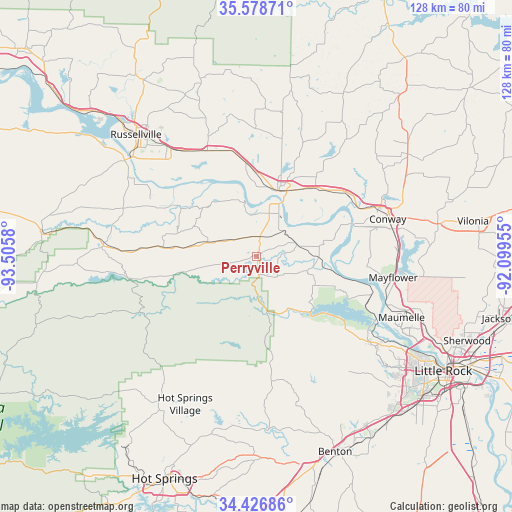
Perryville GPS coordinates[2]
35° 0' 17.316" North, 92° 48' 9.612" West
| Map corner | latitude | longitude |
|---|---|---|
| Upper-left | 35.57871°, | -93.5058° |
| Center: | 35.00481°, | -92.80267° |
| Lower-right: | 34.42686°, | -92.09955° |
| Map W x H: | 128.1×128.1 km | = 79.6×79.6mi |
| max Lat: | 71.29058° ⇑75.4% North |
| Perryville: | 35.00481° |
| min Lat: | ⇓24.6% South 19.06759° |
| min Long | Perryville | max Long |
| -171.73463° | -92.80267° | -66.98998° |
| W 34.1%⇐ | ⇒65.9% E |
Elevation
Elevation of Perryville is 91 m = 299 ft, and this is 203.8 m = 669 ft below average elevation for this country.
| Max E: |
3189 m = 10463 ft | 71.7% |
| Avg. | 294.8 m = 967 ft | |
| Perryville | 91 m = 299 ft | |
Min E: |
-60 m = -197 ft | 28.3% |
See also: United States elevation on elevation.city.
Geographical zone
Perryville is located in North temperate zone (between Tropic of Cancer and the Arctic Circle). Distance of this Northern Tropic circle is 1286.3 km =799.3 mi to South.| Distance of | km | miles | from Perryville |
|---|---|---|---|
| North Pole | 6114.9 | 3799.6 | to North |
| Arctic Circle | 3509 | 2180.4 | to North |
| Tropic Cancer | 1286.3 | 799.3 | to South |
| Equator | 3892.2 | 2418.5 | to South |


Nearby cities:
15 places around Perryville: (largest is in red/bold)
• Atkins
29.5 km =18.3 mi,  335°
335°
• Avilla
41 km =25.5 mi,  151°
151°
• Conway
34.1 km =21.2 mi,  74°
74°
• Dardanelle
40.4 km =25.1 mi,  306°
306°
• Hot Springs Village
41.1 km =25.5 mi,  205°
205°
• Maumelle
39.4 km =24.5 mi,  112°
112°
• Mayflower
34.6 km =21.5 mi,  98°
98°
• Morrilton
17.1 km =10.6 mi,  18°
18°
• Ola
38.4 km =23.9 mi,  274°
274°
• Oppelo
11.2 km =7 mi, 16°
• Plumerville
22.7 km =14.1 mi,  40°
40°
• Pottsville
35.1 km =21.8 mi,  320°
320°
• Roland
30.1 km =18.7 mi, 112°
• Wilson
25.6 km =15.9 mi,  333°
333°
• Wooster
38.4 km =23.9 mi,  55°
55°
Sources, notices
• [Note1] Compared only with cities in United States existing in our database
• [Src1] Map data: © OpenStreetMap contributors (CC-BY-SA)
• [Src2] Other city data from geonames.org with taken over terms of usage.
• [Src3] Geographical zone / Annual Mean Temperature by Robert A. Rohde @ Wikipedia
