Georgetown geodata
Georgetown (Delaware) is a seat of a second-order administrative division; located in United States in America/New_York (GMT-4) time zone. With population of 7,051 people, there are 5783 cities with bigger population in this country. Compared to other cities in United States, 57.5% of cities are located further ↑North; 86.1% of cities are located further ←West and 89.1% of cities have higher elevation than Georgetown. Note1


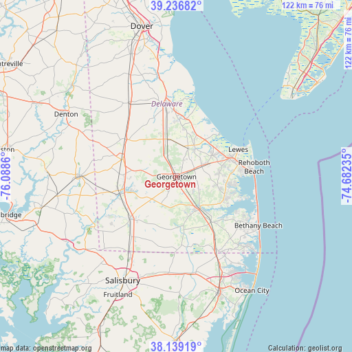
Georgetown GPS coordinates[2]
38° 41' 24.396" North, 75° 23' 7.692" West
| Map corner | latitude | longitude |
|---|---|---|
| Upper-left | 39.23682°, | -76.0886° |
| Center: | 38.69011°, | -75.38547° |
| Lower-right: | 38.13919°, | -74.68235° |
| Map W x H: | 122×122 km | = 75.8×75.8mi |
| max Lat: | 71.29058° ⇑57.5% North |
| Georgetown: | 38.69011° |
| min Lat: | ⇓42.5% South 19.06759° |
| min Long | Georgetown | max Long |
| -171.73463° | -75.38547° | -66.98998° |
| W 86.1%⇐ | ⇒13.9% E |
Elevation
Elevation of Georgetown is 18 m = 59 ft, and this is 276.8 m = 908 ft below average elevation for this country.
| Max E: |
3189 m = 10463 ft | 89.1% |
| Avg. | 294.8 m = 967 ft | |
| Georgetown | 18 m = 59 ft | |
Min E: |
-60 m = -197 ft | 10.9% |
See also: United States elevation on elevation.city.
Geographical zone
Georgetown is located in North temperate zone (between Tropic of Cancer and the Arctic Circle). Distance of this Northern Tropic circle is 1696 km =1053.8 mi to South.| Distance of | km | miles | from Georgetown |
|---|---|---|---|
| North Pole | 5705.1 | 3545 | to North |
| Arctic Circle | 3099.2 | 1925.8 | to North |
| Tropic Cancer | 1696 | 1053.8 | to South |
| Equator | 4301.9 | 2673.1 | to South |


Nearby cities:
15 places around Georgetown: (largest is in red/bold)
• Blades
20.4 km =12.7 mi,  252°
252°
• Bridgeville
19.9 km =12.4 mi,  287°
287°
• Dagsboro
19.8 km =12.3 mi,  142°
142°
• Frankford
23.2 km =14.4 mi,  145°
145°
• Greenwood
22.1 km =13.7 mi,  306°
306°
• Laurel
21.9 km =13.6 mi,  227°
227°
• Lewes
23.3 km =14.5 mi,  66°
66°
• Long Neck
21.8 km =13.5 mi,  110°
110°
• Milford
25 km =15.5 mi,  351°
351°
• Millsboro
13.7 km =8.5 mi, 143°
• Millville
27.6 km =17.1 mi,  124°
124°
• Milton
11.7 km =7.3 mi,  33°
33°
• Rehoboth Beach
27.1 km =16.8 mi,  82°
82°
• Seaford
20.3 km =12.6 mi, 254°
• Selbyville
29.3 km =18.2 mi, 150°
Sources, notices
• [Note1] Compared only with cities in United States existing in our database
• [Src1] Map data: © OpenStreetMap contributors (CC-BY-SA)
• [Src2] Other city data from geonames.org with taken over terms of usage.
• [Src3] Geographical zone / Annual Mean Temperature by Robert A. Rohde @ Wikipedia
