Long Neck geodata
Long Neck (Delaware) is a populated place; located in United States in America/New_York (GMT-4) time zone. With population of 1,980 people, there are 11992 cities with bigger population in this country. Compared to other cities in United States, 57.9% of cities are located further ↑North; 86.9% of cities are located further ←West and 97.4% of cities have higher elevation than Long Neck. Note1


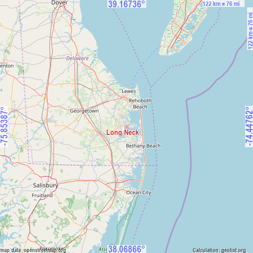
Long Neck GPS coordinates[2]
38° 37' 12.396" North, 75° 9' 2.664" West
| Map corner | latitude | longitude |
|---|---|---|
| Upper-left | 39.16736°, | -75.85387° |
| Center: | 38.62011°, | -75.15074° |
| Lower-right: | 38.06866°, | -74.44762° |
| Map W x H: | 122.2×122.2 km | = 75.9×75.9mi |
| max Lat: | 71.29058° ⇑57.9% North |
| Long Neck: | 38.62011° |
| min Lat: | ⇓42.1% South 19.06759° |
| min Long | Long Neck | max Long |
| -171.73463° | -75.15074° | -66.98998° |
| W 86.9%⇐ | ⇒13.1% E |
Elevation
Elevation of Long Neck is 6 m = 20 ft, and this is 288.8 m = 948 ft below average elevation for this country.
| Max E: |
3189 m = 10463 ft | 97.4% |
| Avg. | 294.8 m = 967 ft | |
| Long Neck | 6 m = 20 ft | |
Min E: |
-60 m = -197 ft | 2.6% |
See also: United States elevation on elevation.city.
Geographical zone
Long Neck is located in North temperate zone (between Tropic of Cancer and the Arctic Circle). Distance of this Northern Tropic circle is 1688.2 km =1049 mi to South.| Distance of | km | miles | from Long Neck |
|---|---|---|---|
| North Pole | 5712.9 | 3549.8 | to North |
| Arctic Circle | 3107 | 1930.6 | to North |
| Tropic Cancer | 1688.2 | 1049 | to South |
| Equator | 4294.2 | 2668.3 | to South |


Nearby cities:
15 places around Long Neck: (largest is in red/bold)
• Bethany Beach
12.2 km =7.6 mi,  137°
137°
• Bishopville
20.1 km =12.5 mi,  190°
190°
• Dagsboro
11.4 km =7.1 mi,  226°
226°
• Frankford
13.6 km =8.5 mi,  212°
212°
• Georgetown
21.8 km =13.5 mi,  290°
290°
• Lewes
17.2 km =10.7 mi,  3°
3°
• Millsboro
12.6 km =7.8 mi,  255°
255°
• Millville
8.2 km =5.1 mi,  163°
163°
• Milton
22.3 km =13.9 mi,  321°
321°
• Ocean City
32.1 km =19.9 mi,  169°
169°
• Ocean Pines
25 km =15.5 mi,  180°
180°
• Ocean View
9.9 km =6.2 mi,  147°
147°
• Rehoboth Beach
13 km =8.1 mi,  30°
30°
• Selbyville
18.8 km =11.7 mi,  198°
198°
• Willards
30.7 km =19.1 mi, 214°
Sources, notices
• [Note1] Compared only with cities in United States existing in our database
• [Src1] Map data: © OpenStreetMap contributors (CC-BY-SA)
• [Src2] Other city data from geonames.org with taken over terms of usage.
• [Src3] Geographical zone / Annual Mean Temperature by Robert A. Rohde @ Wikipedia
