Archer geodata
Archer (Florida) is a populated place; located in United States in America/New_York (GMT-4) time zone. With population of 1,173 people, there are 15272 cities with bigger population in this country. Compared to other cities in United States, 94.5% of cities are located further ↑North; 63.7% of cities are located further ←West and 86.6% of cities have higher elevation than Archer. Note1


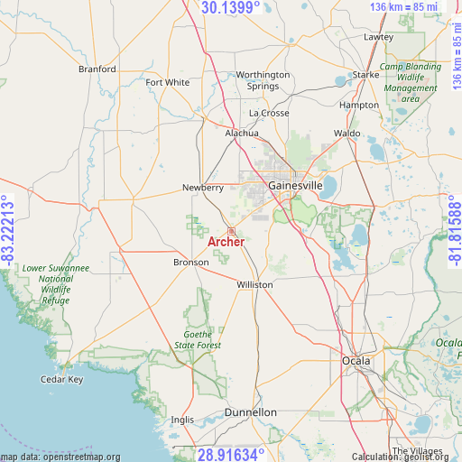
Archer GPS coordinates[2]
29° 31' 47.892" North, 82° 31' 8.4" West
| Map corner | latitude | longitude |
|---|---|---|
| Upper-left | 30.1399°, | -83.22213° |
| Center: | 29.52997°, | -82.519° |
| Lower-right: | 28.91634°, | -81.81588° |
| Map W x H: | 136×136 km | = 84.5×84.5mi |
| max Lat: | 71.29058° ⇑94.5% North |
| Archer: | 29.52997° |
| min Lat: | ⇓5.5% South 19.06759° |
| min Long | Archer | max Long |
| -171.73463° | -82.519° | -66.98998° |
| W 63.7%⇐ | ⇒36.3% E |
Elevation
Elevation of Archer is 24 m = 79 ft, and this is 270.8 m = 888 ft below average elevation for this country.
| Max E: |
3189 m = 10463 ft | 86.6% |
| Avg. | 294.8 m = 967 ft | |
| Archer | 24 m = 79 ft | |
Min E: |
-60 m = -197 ft | 13.4% |
See also: United States elevation on elevation.city.
Geographical zone
Archer is located in North temperate zone (between Tropic of Cancer and the Arctic Circle). Distance of this Northern Tropic circle is 677.5 km =421 mi to South.| Distance of | km | miles | from Archer |
|---|---|---|---|
| North Pole | 6723.6 | 4177.9 | to North |
| Arctic Circle | 4117.7 | 2558.6 | to North |
| Tropic Cancer | 677.5 | 421 | to South |
| Equator | 3283.4 | 2040.2 | to South |


Nearby cities:
15 places around Archer: (largest is in red/bold)
• Alachua
26.3 km =16.3 mi,  20°
20°
• Andrews
35.1 km =21.8 mi,  270°
270°
• Bronson
15 km =9.3 mi,  232°
232°
• Chiefland
33.5 km =20.8 mi,  259°
259°
• East Bronson
10.5 km =6.5 mi,  221°
221°
• East Williston
18.5 km =11.5 mi,  147°
147°
• Gainesville
23.1 km =14.4 mi,  54°
54°
• High Springs
33.9 km =21.1 mi,  347°
347°
• Manatee Road
38.3 km =23.8 mi, 267°
• Micanopy
23.3 km =14.5 mi,  96°
96°
• Newberry
15.5 km =9.6 mi,  326°
326°
• Reddick
36.1 km =22.4 mi,  120°
120°
• Trenton
30.3 km =18.8 mi,  287°
287°
• Williston
17.3 km =10.7 mi,  156°
156°
• Williston Highlands
21.2 km =13.2 mi,  185°
185°
Sources, notices
• [Note1] Compared only with cities in United States existing in our database
• [Src1] Map data: © OpenStreetMap contributors (CC-BY-SA)
• [Src2] Other city data from geonames.org with taken over terms of usage.
• [Src3] Geographical zone / Annual Mean Temperature by Robert A. Rohde @ Wikipedia
