Gainesville geodata
Gainesville (Florida) is a seat of a second-order administrative division; located in United States in America/New_York (GMT-4) time zone. With population of 130,128 people, there are 235 cities with bigger population in this country. Compared to other cities in United States, 94.2% of cities are located further ↑North; 64.5% of cities are located further ←West and 82.3% of cities have higher elevation than Gainesville. Note1


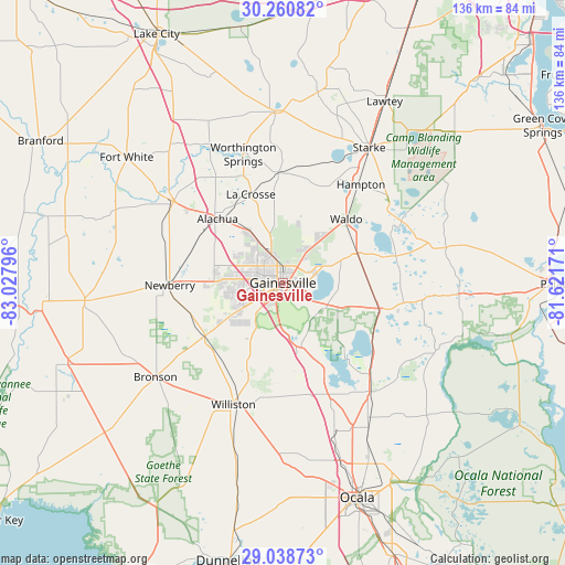
Gainesville GPS coordinates[2]
29° 39' 5.868" North, 82° 19' 29.388" West
| Map corner | latitude | longitude |
|---|---|---|
| Upper-left | 30.26082°, | -83.02796° |
| Center: | 29.65163°, | -82.32483° |
| Lower-right: | 29.03873°, | -81.62171° |
| Map W x H: | 135.9×135.9 km | = 84.4×84.4mi |
| max Lat: | 71.29058° ⇑94.2% North |
| Gainesville: | 29.65163° |
| min Lat: | ⇓5.8% South 19.06759° |
| min Long | Gainesville | max Long |
| -171.73463° | -82.32483° | -66.98998° |
| W 64.5%⇐ | ⇒35.5% E |
Elevation
Elevation of Gainesville is 37 m = 121 ft, and this is 257.8 m = 846 ft below average elevation for this country.
| Max E: |
3189 m = 10463 ft | 82.3% |
| Avg. | 294.8 m = 967 ft | |
| Gainesville | 37 m = 121 ft | |
Min E: |
-60 m = -197 ft | 17.7% |
See also: Gainesville elevation on elevation.city.
Geographical zone
Gainesville is located in North temperate zone (between Tropic of Cancer and the Arctic Circle). Distance of this Northern Tropic circle is 691 km =429.4 mi to South.| Distance of | km | miles | from Gainesville |
|---|---|---|---|
| North Pole | 6710.1 | 4169.5 | to North |
| Arctic Circle | 4104.2 | 2550.2 | to North |
| Tropic Cancer | 691 | 429.4 | to South |
| Equator | 3297 | 2048.7 | to South |


Nearby cities:
15 places around Gainesville: (largest is in red/bold)
• Alachua
14.7 km =9.1 mi,  319°
319°
• Archer
23.1 km =14.4 mi,  234°
234°
• Bronson
38.2 km =23.7 mi, 233°
• Citra
33.8 km =21 mi,  142°
142°
• East Bronson
33.4 km =20.8 mi, 230°
• East Williston
30.5 km =19 mi,  197°
197°
• Hawthorne
23.9 km =14.9 mi,  106°
106°
• High Springs
32.7 km =20.3 mi,  306°
306°
• Keystone Heights
32 km =19.9 mi,  62°
62°
• Micanopy
16.9 km =10.5 mi,  165°
165°
• Newberry
27.2 km =16.9 mi,  268°
268°
• Reddick
34 km =21.1 mi,  158°
158°
• Starke
38.6 km =24 mi,  32°
32°
• Waldo
21.6 km =13.4 mi,  44°
44°
• Williston
31.7 km =19.7 mi, 201°
Sources, notices
• [Note1] Compared only with cities in United States existing in our database
• [Src1] Map data: © OpenStreetMap contributors (CC-BY-SA)
• [Src2] Other city data from geonames.org with taken over terms of usage.
• [Src3] Geographical zone / Annual Mean Temperature by Robert A. Rohde @ Wikipedia
