Astor geodata
Astor (Florida) is a populated place; located in United States in America/New_York (GMT-4) time zone. With population of 1,556 people, there are 13453 cities with bigger population in this country. Compared to other cities in United States, 95.1% of cities are located further ↑North; 67.5% of cities are located further ←West and 94.8% of cities have higher elevation than Astor. Note1


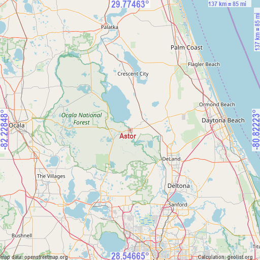
Astor GPS coordinates[2]
29° 9' 44.928" North, 81° 31' 31.26" West
| Map corner | latitude | longitude |
|---|---|---|
| Upper-left | 29.77463°, | -82.22848° |
| Center: | 29.16248°, | -81.52535° |
| Lower-right: | 28.54665°, | -80.82223° |
| Map W x H: | 136.5×136.5 km | = 84.8×84.8mi |
| max Lat: | 71.29058° ⇑95.1% North |
| Astor: | 29.16248° |
| min Lat: | ⇓4.9% South 19.06759° |
| min Long | Astor | max Long |
| -171.73463° | -81.52535° | -66.98998° |
| W 67.5%⇐ | ⇒32.5% E |
Elevation
Elevation of Astor is 9 m = 30 ft, and this is 285.8 m = 938 ft below average elevation for this country.
| Max E: |
3189 m = 10463 ft | 94.8% |
| Avg. | 294.8 m = 967 ft | |
| Astor | 9 m = 30 ft | |
Min E: |
-60 m = -197 ft | 5.2% |
See also: United States elevation on elevation.city.
Geographical zone
Astor is located in North temperate zone (between Tropic of Cancer and the Arctic Circle). Distance of this Northern Tropic circle is 636.6 km =395.6 mi to South.| Distance of | km | miles | from Astor |
|---|---|---|---|
| North Pole | 6764.5 | 4203.3 | to North |
| Arctic Circle | 4158.6 | 2584 | to North |
| Tropic Cancer | 636.6 | 395.6 | to South |
| Equator | 3242.6 | 2014.9 | to South |


Nearby cities:
15 places around Astor: (largest is in red/bold)
• Crescent City
29.8 km =18.5 mi,  2°
2°
• De Land Southwest
27 km =16.8 mi,  129°
129°
• De Leon Springs
17.4 km =10.8 mi,  105°
105°
• DeLand
26.2 km =16.3 mi,  124°
124°
• Lake Helen
34.8 km =21.6 mi, 125°
• Lake Kathryn
16.7 km =10.4 mi,  168°
168°
• Lake Mack-Forest Hills
20.5 km =12.7 mi,  151°
151°
• North DeLand
25.4 km =15.8 mi, 119°
• Orange City
32.4 km =20.1 mi,  137°
137°
• Paisley
20 km =12.4 mi,  184°
184°
• Pierson
10.3 km =6.4 mi,  34°
34°
• Pine Lakes
26.3 km =16.3 mi,  159°
159°
• Seville
17.5 km =10.9 mi,  10°
10°
• Umatilla
29.3 km =18.2 mi,  207°
207°
• West DeLand
24.8 km =15.4 mi, 131°
Sources, notices
• [Note1] Compared only with cities in United States existing in our database
• [Src1] Map data: © OpenStreetMap contributors (CC-BY-SA)
• [Src2] Other city data from geonames.org with taken over terms of usage.
• [Src3] Geographical zone / Annual Mean Temperature by Robert A. Rohde @ Wikipedia
