Lake Mack-Forest Hills geodata
Lake Mack-Forest Hills (Florida) is a populated place; located in United States in America/New_York (GMT-4) time zone. With population of 1,010 people, there are 16223 cities with bigger population in this country. Compared to other cities in United States, 95.2% of cities are located further ↑North; 68% of cities are located further ←West and 86.6% of cities have higher elevation than Lake Mack-Forest Hills. Note1
Current local time in Lake Mack-Forest Hills:
02:49 AM, WednesdayDifference from your time zone: hours


Lake Mack-Forest Hills GPS coordinates[2]
29° 0' 2.664" North, 81° 25' 26.292" West
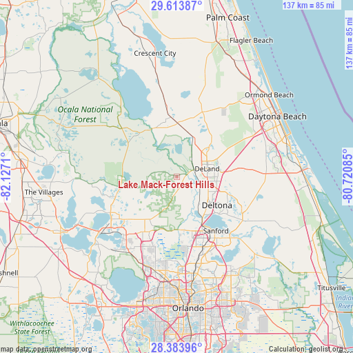
| Map corner | latitude | longitude |
|---|---|---|
| Upper-left | 29.61387°, | -82.1271° |
| Center: | 29.00074°, | -81.42397° |
| Lower-right: | 28.38396°, | -80.72085° |
| Map W x H: | 136.8×136.8 km | = 85×85mi |
| max Lat: | 71.29058° ⇑95.2% North |
| Lake Mack-Forest Hills: | 29.00074° |
| min Lat: | ⇓4.8% South 19.06759° |
| min Long | Lake Mack-Fores | max Long |
| -171.73463° | -81.42397° | -66.98998° |
| W 68%⇐ | ⇒32% E |
Elevation
Elevation of Lake Mack-Forest Hills is 24 m = 79 ft, and this is 270.8 m = 888 ft below average elevation for this country.
| Max E: |
3189 m = 10463 ft | 86.6% |
| Avg. | 294.8 m = 967 ft | |
| Lake Mack-Forest Hills | 24 m = 79 ft | |
Min E: |
-60 m = -197 ft | 13.4% |
See also: United States elevation on elevation.city.
Geographical zone
Lake Mack-Forest Hills is located in North temperate zone (between Tropic of Cancer and the Arctic Circle). Distance of this Northern Tropic circle is 618.7 km =384.4 mi to South.| Distance of | km | miles | from Lake Mack-Forest Hills |
|---|---|---|---|
| North Pole | 6782.5 | 4214.4 | to North |
| Arctic Circle | 4176.6 | 2595.2 | to North |
| Tropic Cancer | 618.7 | 384.4 | to South |
| Equator | 3224.6 | 2003.7 | to South |


Nearby cities:
15 places around Lake Mack-Forest Hills: (largest is in red/bold)
• Astor
20.5 km =12.7 mi,  331°
331°
• De Land Southwest
11 km =6.8 mi,  85°
85°
• De Leon Springs
14.9 km =9.3 mi,  27°
27°
• DeBary
17.2 km =10.7 mi,  139°
139°
• DeLand
12.1 km =7.5 mi,  75°
75°
• Deltona
19.2 km =11.9 mi,  125°
125°
• Lake Helen
18.7 km =11.6 mi,  96°
96°
• Lake Kathryn
6.8 km =4.2 mi,  283°
283°
• Mount Plymouth
23.9 km =14.9 mi,  206°
206°
• North DeLand
13.4 km =8.3 mi,  66°
66°
• Orange City
13.5 km =8.4 mi,  115°
115°
• Paisley
11.6 km =7.2 mi,  260°
260°
• Pine Lakes
6.7 km =4.2 mi,  185°
185°
• Umatilla
24.8 km =15.4 mi,  251°
251°
• West DeLand
9 km =5.6 mi, 79°
Sources, notices
• [Note1] Compared only with cities in United States existing in our database
• [Src1] Map data: © OpenStreetMap contributors (CC-BY-SA)
• [Src2] Other city data from geonames.org with taken over terms of usage.
• [Src3] Geographical zone / Annual Mean Temperature by Robert A. Rohde @ Wikipedia
