Bushnell geodata
Bushnell (Florida) is a seat of a second-order administrative division; located in United States in America/New_York (GMT-4) time zone. With population of 2,995 people, there are 9645 cities with bigger population in this country. Compared to other cities in United States, 95.7% of cities are located further ↑North; 65.2% of cities are located further ←West and 85.8% of cities have higher elevation than Bushnell. Note1


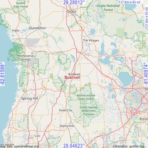
Bushnell GPS coordinates[2]
28° 39' 53.964" North, 82° 6' 46.296" West
| Map corner | latitude | longitude |
|---|---|---|
| Upper-left | 29.28012°, | -82.81599° |
| Center: | 28.66499°, | -82.11286° |
| Lower-right: | 28.04623°, | -81.40974° |
| Map W x H: | 137.2×137.2 km | = 85.3×85.3mi |
| max Lat: | 71.29058° ⇑95.7% North |
| Bushnell: | 28.66499° |
| min Lat: | ⇓4.3% South 19.06759° |
| min Long | Bushnell | max Long |
| -171.73463° | -82.11286° | -66.98998° |
| W 65.2%⇐ | ⇒34.8% E |
Elevation
Elevation of Bushnell is 26 m = 85 ft, and this is 268.8 m = 882 ft below average elevation for this country.
| Max E: |
3189 m = 10463 ft | 85.8% |
| Avg. | 294.8 m = 967 ft | |
| Bushnell | 26 m = 85 ft | |
Min E: |
-60 m = -197 ft | 14.2% |
See also: United States elevation on elevation.city.
Geographical zone
Bushnell is located in North temperate zone (between Tropic of Cancer and the Arctic Circle). Distance of this Northern Tropic circle is 581.3 km =361.2 mi to South.| Distance of | km | miles | from Bushnell |
|---|---|---|---|
| North Pole | 6819.8 | 4237.6 | to North |
| Arctic Circle | 4213.9 | 2618.4 | to North |
| Tropic Cancer | 581.3 | 361.2 | to South |
| Equator | 3187.2 | 1980.4 | to South |


Nearby cities:
15 places around Bushnell: (largest is in red/bold)
• Center Hill
11.9 km =7.4 mi,  98°
98°
• Coleman
15.5 km =9.6 mi,  15°
15°
• Floral City
20.3 km =12.6 mi,  297°
297°
• Groveland
28.2 km =17.5 mi,  114°
114°
• Hawthorne
25.9 km =16.1 mi,  65°
65°
• Hill 'n Dale
24.3 km =15.1 mi,  228°
228°
• Inverness
28.5 km =17.7 mi,  311°
311°
• Inverness Highlands South
26.6 km =16.5 mi, 304°
• Lacoochee
22.9 km =14.2 mi,  194°
194°
• Lake Panasoffkee
10.3 km =6.4 mi,  9°
9°
• Leesburg
28.1 km =17.5 mi,  54°
54°
• Mascotte
24.1 km =15 mi, 113°
• Ridge Manor
18.4 km =11.4 mi,  197°
197°
• Webster
8.3 km =5.2 mi,  137°
137°
• Wildwood
23.4 km =14.5 mi, 17°
Sources, notices
• [Note1] Compared only with cities in United States existing in our database
• [Src1] Map data: © OpenStreetMap contributors (CC-BY-SA)
• [Src2] Other city data from geonames.org with taken over terms of usage.
• [Src3] Geographical zone / Annual Mean Temperature by Robert A. Rohde @ Wikipedia
