Floral City geodata
Floral City (Florida) is a populated place; located in United States in America/New_York (GMT-4) time zone. With population of 5,217 people, there are 6979 cities with bigger population in this country. Compared to other cities in United States, 95.6% of cities are located further ↑North; 64.7% of cities are located further ←West and 86.6% of cities have higher elevation than Floral City. Note1


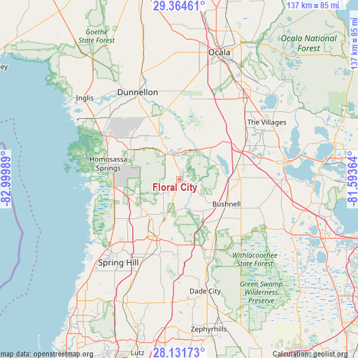
Floral City GPS coordinates[2]
28° 44' 59.964" North, 82° 17' 48.336" West
| Map corner | latitude | longitude |
|---|---|---|
| Upper-left | 29.36461°, | -82.99989° |
| Center: | 28.74999°, | -82.29676° |
| Lower-right: | 28.13173°, | -81.59364° |
| Map W x H: | 137.1×137.1 km | = 85.2×85.2mi |
| max Lat: | 71.29058° ⇑95.6% North |
| Floral City: | 28.74999° |
| min Lat: | ⇓4.4% South 19.06759° |
| min Long | Floral City | max Long |
| -171.73463° | -82.29676° | -66.98998° |
| W 64.7%⇐ | ⇒35.3% E |
Elevation
Elevation of Floral City is 24 m = 79 ft, and this is 270.8 m = 888 ft below average elevation for this country.
| Max E: |
3189 m = 10463 ft | 86.6% |
| Avg. | 294.8 m = 967 ft | |
| Floral City | 24 m = 79 ft | |
Min E: |
-60 m = -197 ft | 13.4% |
See also: United States elevation on elevation.city.
Geographical zone
Floral City is located in North temperate zone (between Tropic of Cancer and the Arctic Circle). Distance of this Northern Tropic circle is 590.8 km =367.1 mi to South.| Distance of | km | miles | from Floral City |
|---|---|---|---|
| North Pole | 6810.4 | 4231.8 | to North |
| Arctic Circle | 4204.5 | 2612.6 | to North |
| Tropic Cancer | 590.8 | 367.1 | to South |
| Equator | 3196.7 | 1986.3 | to South |


Nearby cities:
15 places around Floral City: (largest is in red/bold)
• Beverly Hills
24.3 km =15.1 mi,  319°
319°
• Brooksville
23.5 km =14.6 mi,  202°
202°
• Bushnell
20.3 km =12.6 mi,  117°
117°
• Citrus Hills
20.3 km =12.6 mi, 319°
• Coleman
22.8 km =14.2 mi,  75°
75°
• Hernando
18.3 km =11.4 mi,  335°
335°
• Hill 'n Dale
25.6 km =15.9 mi,  180°
180°
• Inverness
10.1 km =6.3 mi, 341°
• Inverness Highlands North
14.9 km =9.3 mi,  328°
328°
• Inverness Highlands South
6.9 km =4.3 mi, 325°
• Lake Panasoffkee
19.7 km =12.2 mi,  88°
88°
• Lecanto
21.8 km =13.5 mi,  301°
301°
• North Brooksville
22.5 km =14 mi,  208°
208°
• South Brooksville
25.3 km =15.7 mi, 199°
• Sugarmill Woods
20.5 km =12.7 mi,  264°
264°
Sources, notices
• [Note1] Compared only with cities in United States existing in our database
• [Src1] Map data: © OpenStreetMap contributors (CC-BY-SA)
• [Src2] Other city data from geonames.org with taken over terms of usage.
• [Src3] Geographical zone / Annual Mean Temperature by Robert A. Rohde @ Wikipedia
