Chumuckla geodata
Chumuckla (Florida) is a populated place; located in United States in America/Chicago (GMT-5) time zone. With population of 850 people, there are 17359 cities with bigger population in this country. Compared to other cities in United States, 91.1% of cities are located further ↑North; 50.2% of cities are located further →East and 76.5% of cities have higher elevation than Chumuckla. Note1


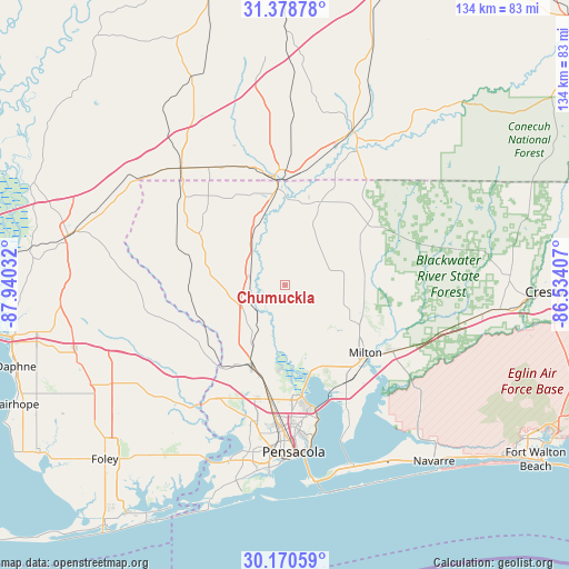
Chumuckla GPS coordinates[2]
30° 46' 35.688" North, 87° 14' 13.884" West
| Map corner | latitude | longitude |
|---|---|---|
| Upper-left | 31.37878°, | -87.94032° |
| Center: | 30.77658°, | -87.23719° |
| Lower-right: | 30.17059°, | -86.53407° |
| Map W x H: | 134.3×134.3 km | = 83.5×83.5mi |
| max Lat: | 71.29058° ⇑91.1% North |
| Chumuckla: | 30.77658° |
| min Lat: | ⇓8.9% South 19.06759° |
| min Long | Chumuckla | max Long |
| -171.73463° | -87.23719° | -66.98998° |
| W 49.8%⇐ | ⇒50.2% E |
Elevation
Elevation of Chumuckla is 63 m = 207 ft, and this is 231.8 m = 760 ft below average elevation for this country.
| Max E: |
3189 m = 10463 ft | 76.5% |
| Avg. | 294.8 m = 967 ft | |
| Chumuckla | 63 m = 207 ft | |
Min E: |
-60 m = -197 ft | 23.5% |
See also: United States elevation on elevation.city.
Geographical zone
Chumuckla is located in North temperate zone (between Tropic of Cancer and the Arctic Circle). Distance of this Northern Tropic circle is 816.1 km =507.1 mi to South.| Distance of | km | miles | from Chumuckla |
|---|---|---|---|
| North Pole | 6585 | 4091.7 | to North |
| Arctic Circle | 3979.1 | 2472.5 | to North |
| Tropic Cancer | 816.1 | 507.1 | to South |
| Equator | 3422 | 2126.3 | to South |


Nearby cities:
15 places around Chumuckla: (largest is in red/bold)
• Allentown
18.7 km =11.6 mi,  94°
94°
• Bagdad
27.8 km =17.3 mi,  135°
135°
• Cantonment
21.1 km =13.1 mi,  207°
207°
• Century
22 km =13.7 mi,  353°
353°
• East Milton
27.3 km =17 mi,  131°
131°
• Ensley
28.9 km =18 mi,  186°
186°
• Flomaton
25 km =15.5 mi, 354°
• Gonzalez
22.3 km =13.9 mi, 193°
• Jay
21.3 km =13.2 mi,  22°
22°
• Milton
24.8 km =15.4 mi, 130°
• Molino
9.4 km =5.8 mi,  231°
231°
• Pace
21 km =13 mi,  159°
159°
• Point Baker
20 km =12.4 mi,  118°
118°
• Roeville
25.8 km =16 mi, 115°
• Wallace
12.3 km =7.6 mi,  153°
153°
Sources, notices
• [Note1] Compared only with cities in United States existing in our database
• [Src1] Map data: © OpenStreetMap contributors (CC-BY-SA)
• [Src2] Other city data from geonames.org with taken over terms of usage.
• [Src3] Geographical zone / Annual Mean Temperature by Robert A. Rohde @ Wikipedia
