East Milton geodata
East Milton (Florida) is a populated place; located in United States in America/Chicago (GMT-5) time zone. With population of 11,074 people, there are 4161 cities with bigger population in this country. Compared to other cities in United States, 91.5% of cities are located further ↑North; 50.2% of cities are located further ←West and 93.9% of cities have higher elevation than East Milton. Note1


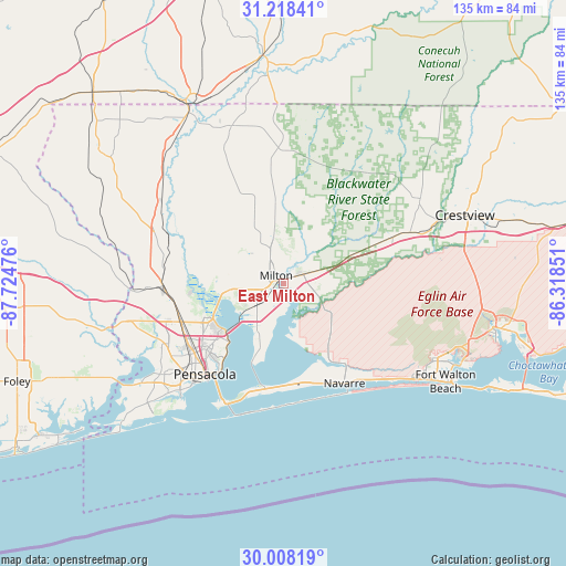
East Milton GPS coordinates[2]
30° 36' 54.684" North, 87° 1' 17.868" West
| Map corner | latitude | longitude |
|---|---|---|
| Upper-left | 31.21841°, | -87.72476° |
| Center: | 30.61519°, | -87.02163° |
| Lower-right: | 30.00819°, | -86.31851° |
| Map W x H: | 134.6×134.6 km | = 83.6×83.6mi |
| max Lat: | 71.29058° ⇑91.5% North |
| East Milton: | 30.61519° |
| min Lat: | ⇓8.5% South 19.06759° |
| min Long | East Milton | max Long |
| -171.73463° | -87.02163° | -66.98998° |
| W 50.2%⇐ | ⇒49.8% E |
Elevation
Elevation of East Milton is 10 m = 33 ft, and this is 284.8 m = 934 ft below average elevation for this country.
| Max E: |
3189 m = 10463 ft | 93.9% |
| Avg. | 294.8 m = 967 ft | |
| East Milton | 10 m = 33 ft | |
Min E: |
-60 m = -197 ft | 6.1% |
See also: United States elevation on elevation.city.
Geographical zone
East Milton is located in North temperate zone (between Tropic of Cancer and the Arctic Circle). Distance of this Northern Tropic circle is 798.2 km =496 mi to South.| Distance of | km | miles | from East Milton |
|---|---|---|---|
| North Pole | 6603 | 4102.9 | to North |
| Arctic Circle | 3997.1 | 2483.7 | to North |
| Tropic Cancer | 798.2 | 496 | to South |
| Equator | 3404.1 | 2115.2 | to South |


Nearby cities:
15 places around East Milton: (largest is in red/bold)
• Allentown
16.5 km =10.3 mi,  353°
353°
• Bagdad
2.1 km =1.3 mi,  209°
209°
• Brent
26.2 km =16.3 mi,  231°
231°
• East Pensacola Heights
25.7 km =16 mi,  216°
216°
• Ferry Pass
21.7 km =13.5 mi,  237°
237°
• Gonzalez
26.1 km =16.2 mi,  261°
261°
• Harold
14.4 km =8.9 mi,  70°
70°
• Holley
21.7 km =13.5 mi,  149°
149°
• Midway
23.3 km =14.5 mi,  176°
176°
• Milton
2.6 km =1.6 mi,  317°
317°
• Pace
13.5 km =8.4 mi, 262°
• Point Baker
8.9 km =5.5 mi,  339°
339°
• Roeville
7.4 km =4.6 mi,  21°
21°
• Wallace
16.7 km =10.4 mi,  294°
294°
• Woodlawn Beach
25.4 km =15.8 mi,  173°
173°
Sources, notices
• [Note1] Compared only with cities in United States existing in our database
• [Src1] Map data: © OpenStreetMap contributors (CC-BY-SA)
• [Src2] Other city data from geonames.org with taken over terms of usage.
• [Src3] Geographical zone / Annual Mean Temperature by Robert A. Rohde @ Wikipedia
