Citrus Ridge geodata
Citrus Ridge (Florida) is a populated place; located in United States in America/New_York (GMT-4) time zone. With population of 13,285 people, there are 3602 cities with bigger population in this country. Compared to other cities in United States, 96.2% of cities are located further ↑North; 66.9% of cities are located further ←West and 83.2% of cities have higher elevation than Citrus Ridge. Note1


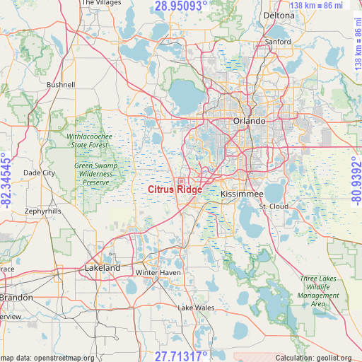
Citrus Ridge GPS coordinates[2]
28° 20' 1.86" North, 81° 38' 32.352" West
| Map corner | latitude | longitude |
|---|---|---|
| Upper-left | 28.95093°, | -82.34545° |
| Center: | 28.33385°, | -81.64232° |
| Lower-right: | 27.71317°, | -80.9392° |
| Map W x H: | 137.6×137.6 km | = 85.5×85.5mi |
| max Lat: | 71.29058° ⇑96.2% North |
| Citrus Ridge: | 28.33385° |
| min Lat: | ⇓3.8% South 19.06759° |
| min Long | Citrus Ridge | max Long |
| -171.73463° | -81.64232° | -66.98998° |
| W 66.9%⇐ | ⇒33.1% E |
Elevation
Elevation of Citrus Ridge is 34 m = 112 ft, and this is 260.8 m = 856 ft below average elevation for this country.
| Max E: |
3189 m = 10463 ft | 83.2% |
| Avg. | 294.8 m = 967 ft | |
| Citrus Ridge | 34 m = 112 ft | |
Min E: |
-60 m = -197 ft | 16.8% |
See also: United States elevation on elevation.city.
Geographical zone
Citrus Ridge is located in North temperate zone (between Tropic of Cancer and the Arctic Circle). Distance of this Northern Tropic circle is 544.5 km =338.3 mi to South.| Distance of | km | miles | from Citrus Ridge |
|---|---|---|---|
| North Pole | 6856.6 | 4260.5 | to North |
| Arctic Circle | 4250.7 | 2641.3 | to North |
| Tropic Cancer | 544.5 | 338.3 | to South |
| Equator | 3150.4 | 1957.6 | to South |


Nearby cities:
15 places around Citrus Ridge: (largest is in red/bold)
• Bay Hill
19.4 km =12.1 mi,  39°
39°
• Campbell
20 km =12.4 mi,  114°
114°
• Celebration
10.7 km =6.6 mi,  95°
95°
• Davenport
19.6 km =12.2 mi,  168°
168°
• Doctor Phillips
19.5 km =12.1 mi,  48°
48°
• Four Corners
0.5 km =0.3 mi,  257°
257°
• Gotha
24.5 km =15.2 mi,  28°
28°
• Horizon West
11.3 km =7 mi,  9°
9°
• Hunters Creek
21.7 km =13.5 mi,  82°
82°
• Kissimmee
22.3 km =13.9 mi, 98°
• Lake Butler
21.1 km =13.1 mi, 27°
• Loughman
12.6 km =7.8 mi,  144°
144°
• Tangelo Park
23.5 km =14.6 mi, 54°
• Williamsburg
21.5 km =13.4 mi,  65°
65°
• Windermere
20.8 km =12.9 mi, 30°
Sources, notices
• [Note1] Compared only with cities in United States existing in our database
• [Src1] Map data: © OpenStreetMap contributors (CC-BY-SA)
• [Src2] Other city data from geonames.org with taken over terms of usage.
• [Src3] Geographical zone / Annual Mean Temperature by Robert A. Rohde @ Wikipedia
